Support the Timberjay by making a donation.

A summery September
Calendar may say it’s fall, but temperatures this past month were in line with August
REGIONAL— The calendar last month may have said September, but Mother Nature was still thinking summer. “You just had a typical August,” said Kenny Blumenfeld, one of the …
This item is available in full to subscribers.
Attention subscribers
To continue reading, you will need to either log in to your subscriber account, below, or purchase a new subscription.
Please log in to continue |
A summery September
Calendar may say it’s fall, but temperatures this past month were in line with August

REGIONAL— The calendar last month may have said September, but Mother Nature was still thinking summer.
“You just had a typical August,” said Kenny Blumenfeld, one of the state’s climatologists, commenting this week on what was the second-straight exceptionally warm September in Minnesota. In International Falls, which hosts far northern Minnesota’s longest period of data, this September appears headed for the record books as the second warmest ever recorded, with an average monthly temperature of 62.3 degrees F, finishing just behind the 62.8 degree mark set way back in 1920. A typical September averages 54.2 degrees in the border city.
This past month was right in line with an average August, where the average monthly temperature in International Falls typically comes in at 62.8 degrees.
It turns out that summer-like warmth in Minnesota’s first month of meteorological fall is becoming a pattern, notes Blumenfeld, as ten out of the last 11 Septembers have been warmer than the 30-year average. Five of the top ten warmest Septembers of all time, in a statewide climate record going back at least 125 years, have all occurred since 2000, while the top three warmest have all been recorded in just the past ten years. “September is really showing up as a summer month these days,” said Blumenfeld. “If the changes we see in September are sustained long-term, that would be a fundamental change in our growing season.”
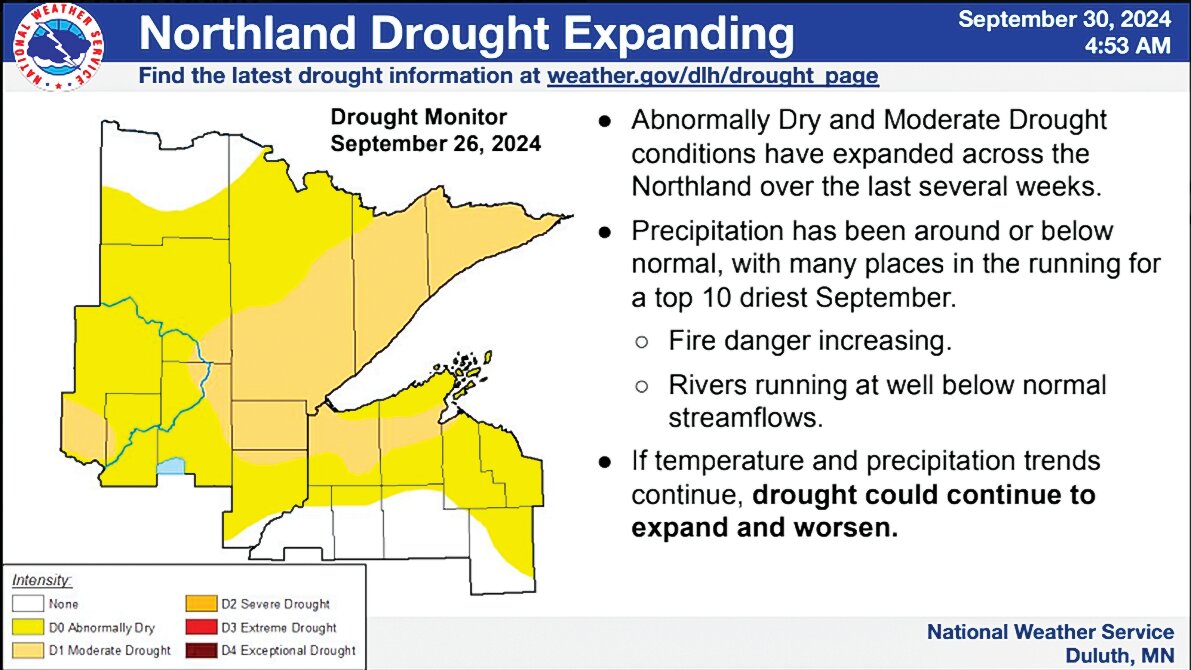
But this past September wasn’t just exceptionally warm. With only a few exceptions, it was exceptionally dry as well as a nearly continental-wide high-pressure system refused to budge, bringing weeks of warm and dry weather to the western two-thirds of the U.S. and much of Canada.
“It’s a very strange pattern,” said Blumenfeld, who notes that it’s highly unusual to be at or near record setting in the same month for both temperature and precipitation.
“It’s possible that this will be both the warmest and driest September on record,” he said, while acknowledging that it will likely take some time to crunch all the weather data to know for sure. “I think we can safely say that no September this warm has ever been this dry,” he said.
But what makes this pattern even more unusual is the vast geographical scale of the high-pressure system that is contributing to the extraordinary conditions. “Typically, whenever we experience a flash drought, like what we’re seeing now, someone the next state or two over is getting hammered by rain,” said Blumenfeld. In other words, flash droughts are usually created through the luck of the draw, as precipitation systems simply miss certain areas.
But that’s not what’s happening this year, notes Blumenfeld. “In this case, there are no persistent rainfall events happening anywhere nationwide, except in the Southeast with the hurricanes.”
The persistent high pressure has cut off most of the country’s mid-section from the Gulf of Mexico, which typically provides the moisture that fuels precipitation in the eastern half of the country. From a meteorological standpoint, said Blumenfeld, the current weather map is extraordinarily rare. “You just don’t see this,” he said. “I can’t remember a time when high pressure dominated virtually the entire country… almost the entire continent.”
The impacts were being seen in the rapid drying of soil across most of northeastern Minnesota, where the regional average for precipitation this month came in at just 0.58 inches, almost three inches below average. International Falls and Kabetogama, which were hit with a significant thunderstorm that dropped about three inches of rain two weeks ago, were the only stations in the region reporting close to normal precipitation for the month.
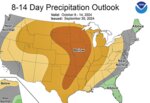
Trend expected to continue
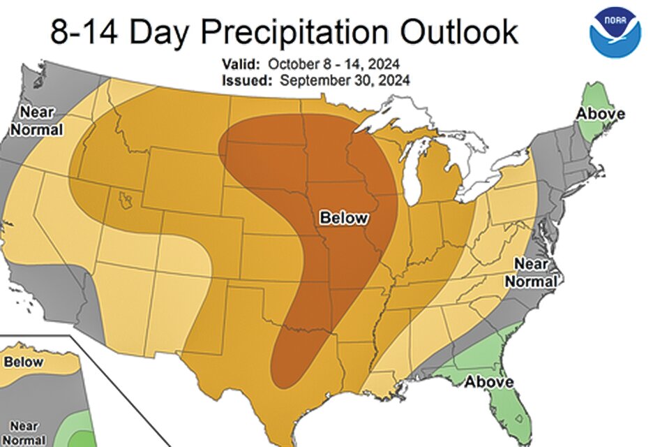
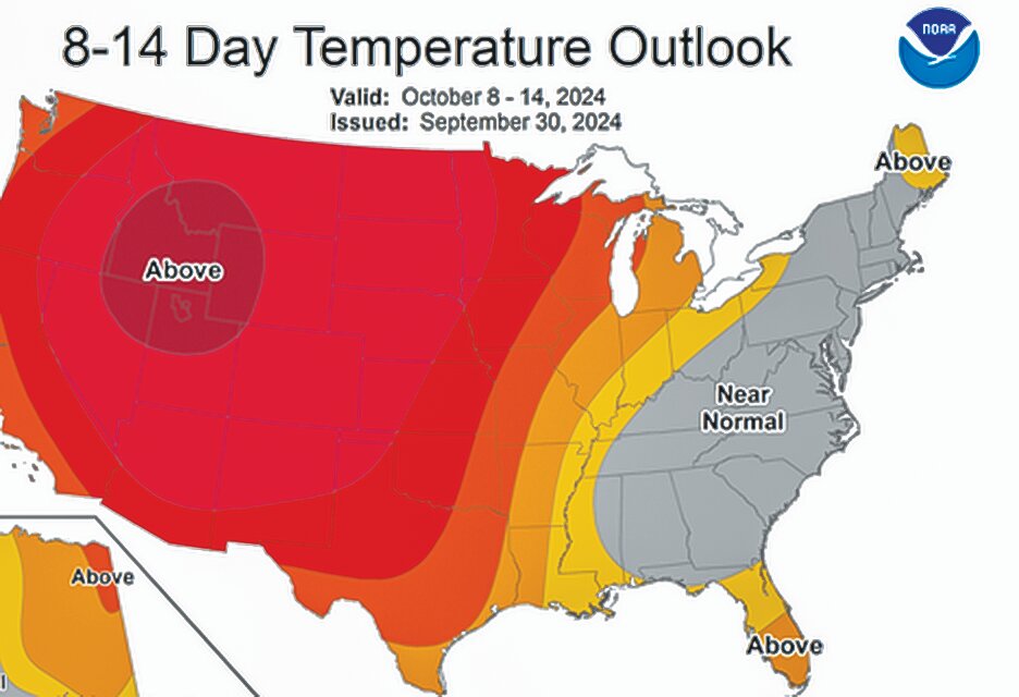
The unusual pattern that brought such warm and dry weather to the North Country in September is expected to continue well into October, according to the National Climate Prediction Center, which is forecasting a high probability of continued above average temperatures and below average precipitation across virtually the entire western two-thirds of the country, including Minnesota, through at least the middle of the month.
Longer term seasonal forecasts predict that the warm and dry trend will eventually break down and a more normal pattern will take hold across the northern tier of states heading into winter.
Last winter’s extraordinary warmth was fueled by the warm el Niño currents that set up in the Pacific. This year, neutral conditions are expected to transition to a weak la Niña pattern by later this fall or early winter. Similar conditions traditionally lead to warm and dry fall, followed by an abrupt change to winter weather. Over the winter, a weak la Niña pattern typically brings colder than average temperatures and near average to slightly above average precipitation. The National Weather Service is expected to release its official winter outlook later this month. The Timberjay will report on their prediction when it becomes available.


