Support the Timberjay by making a donation.

Area water levels tumble
While most of Minnesota has seen record rainfall, the North Country is parched
REGIONAL—Intensifying drought over the past few months has sent water levels in lakes and streams plummeting in much of northern St. Louis County.
And that’s causing problems for boaters, as …
This item is available in full to subscribers.
Attention subscribers
To continue reading, you will need to either log in to your subscriber account, or purchase a new subscription.
If you are a current print subscriber, you can set up a free website account and connect your subscription to it by clicking here.
If you are a digital subscriber with an active, online-only subscription then you already have an account here. Just reset your password if you've not yet logged in to your account on this new site.
Otherwise, click here to view your options for subscribing.
Please log in to continue |
Area water levels tumble
While most of Minnesota has seen record rainfall, the North Country is parched


REGIONAL—Intensifying drought over the past few months has sent water levels in lakes and streams plummeting in much of northern St. Louis County.
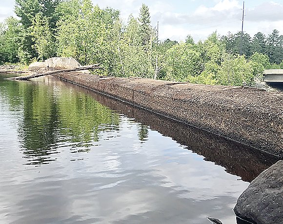
And that’s causing problems for boaters, as water levels have dropped to levels not seen in several years. “We’re probably selling a prop a day right now,” said John Niemiste at Aronson Boat Works on Lake Vermilion, who advises boaters to be extra cautious when traveling on the lake right now. While many of Vermilion’s more hazardous reefs are marked by buoys, Niemiste said the drop in water levels means there are plenty more hazards right now than most boaters have come to expect.
The dramatic fall in water levels on Vermilion is not just surprising boaters, it’s making mail delivery more difficult. “We’ve actually given notices to some of our mailboat customers, saying we can’t get to their docks right now,” said Niemiste, who contracts with the postal service for mail delivery to dozens of water- access residences on the lake.
“It started at about the 4th of July and levels have really dropped a lot recently,” said Niemiste.
“Even pontoons, which normally ride pretty high in the water, are starting to hit. We had three pontoons in here last week that had hit really hard.”
Vermilion isn’t the only lake to have seen a dramatic fall-off in water levels. Even spring-fed lakes like the Eagles Nest chain are seeing lower levels as well. “People need to be aware that just because they traveled over an area before doesn’t mean its safe right now,” said Niemiste.
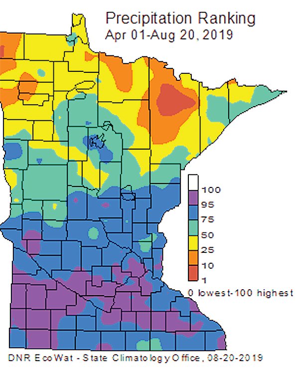
While much of the rest of the state has experienced extraordinarily wet weather this summer, most major precipitation events have passed south of the Laurentian Divide, and that’s stressed forests on shallow soils and left many area gardens and fields parched.
According to the most recent precipitation data mapped by the state climatology office (see map this page), precipitation in most of northern St. Louis County since April 1 is running below the tenth percentile. Average precipitation would be rated near the 50th percentile, while wet conditions could push into the 80th-100th percentiles. Parts of southern Minnesota have experienced some of the wettest conditions on record for this same period, at above the 95th percentile.
As the precipitation ranking map included here suggests, the driest conditions are found in a relatively narrow band in northern St. Louis County. The U.S. Drought Monitor is also showing abnormally dry conditions across a broad swath of St. Louis County, as indicated by the shaded yellow on the map on the next page.
National Weather Service observers in Orr and Cook have reported the largest precipitation deficits in the state since April 1, with total precipitation running nearly six inches below average during that time.
“That’s pretty substantial,” said state climatologist Pete Boulay. “It’s definitely building up a deficit.”
The situation has worsened in August. So far this month, the official Cook reporting station has reported just 0.49 inches of rain while the official Orr station has recorded just 0.54 inches. Typically, summer months in the North Country bring about an inch of rain per week, but most of northern St. Louis County has seen less than an inch so far this month.
The dry conditions have sent water levels on the Vermilion, Pike, and Littlefork rivers plummeting over the past three weeks, particularly in comparison to the high water levels experienced earlier this year in the wake of a wetter than average winter and early spring. Flow on the Littlefork River, for example, has fallen from 344 cubic-feet-per-second (cfs) as of July 30, to just 92 cfs as of Monday’s DNR stream report. Flow on the Vermilion River has dropped from 403 cfs as of July 30, to just 140 cfs as of this week.
As of Monday, the Littlefork’s flow was just barely above its Q90 level of 88 cfs, which is a threshold at which water appropriations from rivers and streams are typically suspended in order to protect aquatic life.
The Vermilion, Littlefork, and St. Louis rivers are the only streams in the state currently listed as in low flow. The Pike River is not included in the weekly stream flow assessment, but conditions for the Pike are similarly low.


