Support the Timberjay by making a donation.

As snowpack grows risks rising as well
Wet first week of April could well add to the problem
REGIONAL- Some of the densest snowpack on record is elevating the risk for spring flooding in the Rainy River basin again this year, but the risk still appears to be less than the conditions that …
This item is available in full to subscribers.
Attention subscribers
To continue reading, you will need to either log in to your subscriber account, or purchase a new subscription.
If you are a current print subscriber, you can set up a free website account and connect your subscription to it by clicking here.
If you are a digital subscriber with an active, online-only subscription then you already have an account here. Just reset your password if you've not yet logged in to your account on this new site.
Otherwise, click here to view your options for subscribing.
Please log in to continue |
As snowpack grows risks rising as well
Wet first week of April could well add to the problem
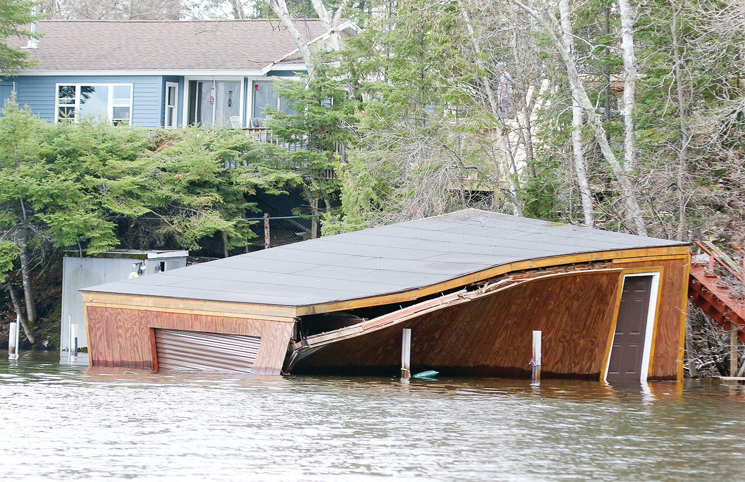


REGIONAL- Some of the densest snowpack on record is elevating the risk for spring flooding in the Rainy River basin again this year, but the risk still appears to be less than the conditions that precipitated last year’s historic flooding.
That’s the message from National Weather Service Duluth office meteorologists conveyed last week in their most recent video conference on the potential for flooding in northeastern Minnesota river basins, where the snowpack contains what meteorologist Joe Moore described as “an extreme to near record amount of water.”
“The potential for spring flooding across the Northland is above normal, but for the Rainy River Basin the risk appears to be not as great as it was last year,” Moore said. “Still, the risk for flooding in the Rainy basin is above normal. Spring flooding is highly dependent on our weather pattern in the coming six to eight weeks. A dry pattern could lead to less flooding, while a wet pattern could push the risk for flooding higher.”
The weather service was forecasting another several inches of snow Thursday night this week with additional snow and possible rain forecast for the first week of April. That’s on top of a deep and dense snowpack that holds a near-record amount of water in some parts of the region.
“We have a widespread four to seven inches of water in the snowpack for pretty much the entire region, maybe a tiny bit less over over parts of the Rainy but a pretty much widespread four to seven,” said meteorologist Ketzel Levens.
Actual snow water equivalent (SWE) amounts as measured by volunteers are generally higher in the eastern portion of the Rainy River basin, with 5.8 inches of SWE near Ely, 5.3 inches southeast of Tower, 5.3 inches near Kabetogama, and 4.1 to 4.5 inches in Koochiching County. SWE measurements along the areas bordering Lake Superior are significantly higher, ranging up to a high of 12-13 inches.
“Most of our basins are in the top 80 to 100 percent of the historical record, many of them in the top 10 percent of snow water equivalent, the lowest being in the Rainy,” Levens said.
Another issue factoring in to the NWS flood risk assessment is that this year’s snow melt is delayed compared to last year’s.
“In mid to late March of 2022, we already started to melt out, and obviously we’re not seeing that yet this year. There’s still widespread snow over portions of northern Minnesota and the South Shore,” Levens said. “It’s not normal to have this much snow on the ground this time of year.”
“The rate of snow melt thing is kind of crazy,” Moore added. “Usually what we do is we do three updates for the spring snow melt flooding and we do our last one in early March because by early March the snow is melting. And we don’t even have that yet. So, it’s certainly a contrast from what we consider like an average year.”
Levens noted that it can be difficult to make direct comparisons with last year because the NWS has many more observations this year and therefore a better overall picture of SWE amounts.
“We’ve been actively recruiting observers to take these SWE observations and we’ve been doing snow surveys with some of our partners as well,” she said.
There’s little to no ground frost in the region, Moore said, which could mitigate some of the effects of the high SWE and resulting runoff when the snowpack melts.
“The good news this spring is that we do not have a very deep frost, there’s little to no frost in the ground,” Moore said. “Last spring, we were coming out of the winter with a really deep frost, so when that snow melted, it had nowhere to go but into our rivers and streams.”
And Levens noted that drought conditions that preceded last year’s snowfall have largely disappeared, and with more moisture in the soil this year it can become saturated more quickly.
Weather conditions
As with any year, temperatures and precipitation in the weeks ahead will determine what happens with spring flooding.
“We don’t think that we’re going to be able to get by with this year with no flooding whatsoever, there’s so much water sitting on the ground, there will be some amount of flooding,” Moore said. “But the weather really is going to drive whether this is a bad year or a really bad year.”
For the snow melt, Moore said that ideally a pattern of freezing at night with above freezing temperatures during the day would be most favorable for a gradual snow melt, and the predictions through this week were for exactly that pattern, along with little chance of any precipitation.
“Looking at late March and then kind of the first week of April, the good news there is we do have below normal temperatures forecast. So, if we can remain in a cold, cool pattern that will slow the melt. If we see a reversal in this pattern and it does warm up again, that could be bad. For the month of April there’s approximately equal chances of seeing above normal or below normal temperatures.”
The precipitation outlook for April is leaning slightly above normal, Moore said.
“That isn’t great, but overall it’s a fairly neutral impact,” he said. “The longer we delay it, that’s good. But as we get into the warmer and warmer weeks of April and then into early May, we have a greater potential for a rain-on-snow event, rain falling on snow that melts it right away, much quicker than it would otherwise. That can really create some fast rises on rivers.”
For the months of April, May, and June, the precipitation pattern is predicted to be slightly above normal, Moore said, while temperatures have an equal chance to be slightly below normal.
“The cooler the better, honestly,” he said. “The cooler it is the greater chance snowpack sticks around, and again we want it to go away slowly. We want to avoid heavy rainfall events through at least early May.”
Moore and Levens had some predictive percentages for the likelihood of flooding in the Upper Mississippi Basin, with a greater than 95 percent chance of moderate flooding near Aitkin, but didn’t have similar projections calculated for the Rainy River basin.
“We are working on getting forecast points developed for some of some areas in the Rainy River Basin. Unfortunately, those aren’t quite ready to go yet,” Levens said. “There’s quite a bit of kind of spin up that has to happen on those. So, we don’t have exact forecast point numbers as far as percentages of minor, moderate, and major flooding. We all keep high situational awareness for the Rainy River Basin, however. We are still running our Rainy River page on our website, weather.gov/dlh/rainyriverbasin. And we still have all of the hydrographs, all the current information that is up and running. But unfortunately, we don’t have those exact percentiles as far as for flood risk because they haven’t been fully developed yet.”
Moore said another NWS update on conditions will be provided by April 7. Meanwhile, the Water Levels Committee of the International Rainy-Lake of the Woods Watershed Board will host a virtual information session about conditions in the Rainy River basin on Tuesday, April 11 at 7 p.m. This session will include snowpack and forecast information the committee is considering in its spring regulation plan for lake levels. A link to register for that virtual meeting is available at https://ijc.org/en/rlwwb/international-rainy-lake-woods-watershed-boards-water-levels-committee-host-virtual-public.


