Support the Timberjay by making a donation.

Greenwood Fire contained; BWCAW fully opened
Prescribed burns could resume this autumn
REGIONAL - The U.S. Forest Service reduced the Greenwood Fire closure last weekend to the perimeter of the fire area, citing containment of the fire and decreasing fire risk. USFS forest fire …
This item is available in full to subscribers.
Attention subscribers
To continue reading, you will need to either log in to your subscriber account, or purchase a new subscription.
If you are a current print subscriber, you can set up a free website account and connect your subscription to it by clicking here.
If you are a digital subscriber with an active, online-only subscription then you already have an account here. Just reset your password if you've not yet logged in to your account on this new site.
Otherwise, click here to view your options for subscribing.
Please log in to continue |
Greenwood Fire contained; BWCAW fully opened
Prescribed burns could resume this autumn
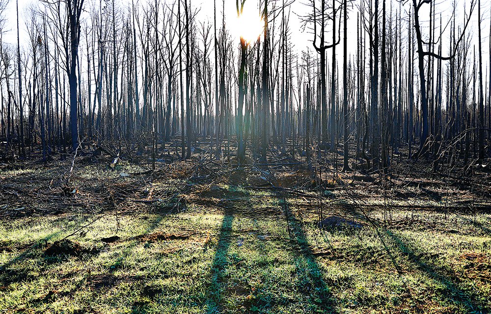
REGIONAL - The U.S. Forest Service reduced the Greenwood Fire closure last weekend to the perimeter of the fire area, citing containment of the fire and decreasing fire risk. USFS forest fire managers hope to transition to conducting some prescribed burns this fall, mainly pile burning, if fuel and weather conditions allow.
The Minnesota Incident Command Team transferred responsibility of the Greenwood Fire back to the Superior National Forest last Friday, according to Public Information Officer Tim Engrav.
“The Forest is keeping a closure in place around the fire perimeter because some heat has been observed within the interior, along with snags and hazard trees being present in the fire area,” he said. “We ask that the public act with caution when traveling through the area due to these hazards.”
The reduced closure is generally south of Highway 1 and extends to the northern edge of Greenwood Lake. Forest lands and roads within the closure area will remain closed, including McDougal Lake Campground and all associated recreation areas, and the Stony River Observation Point. Little Isabella Campground is also closed due to heavy use from firefighters, and bear sightings. This closure area will be in place until further notice.
Maximum containment of the Greenwood Fire peaked at 80-81 percent, as wetland areas prevented crew and equipment from building containment lines in those areas, according to Engrav.
“Where the lines have been cold and secure, crews and equipment have been working to repair the impacts of line construction and restore them to a near natural state to reduce the potential for erosion or other natural resource impacts,” he said.
Equipment and hand crews will rehabilitate and repair containment lines including the finishing work of seeding those areas with native grass seed to stabilize the surface soils. Crews removed hazard trees along the closed section of the Jackpot ATV Trail impacted by the fire.
In addition, trees and debris will be cleaned up and removed from the McDougal Boat Access area this week.
“The backhaul of pumps, hoses, and other supplies will be done as they are no longer needed on parts of the fire. A gradual process of downsizing equipment and personnel will be followed based on the amount of work remaining,” Engrav added.
The McDougal Lake Road, North McDougal Lake Road, Middle Road, and Stony Loop Road in the Greenwood Fire closure area are open to property owners via a security pass card from the Lake County Sheriff.
BWCAW closures
Last weekend, the Forest Service also lifted the last of the closures in the Boundary Waters Canoe Area Wilderness, the John Ek and Whelp Fire closures, citing low fire activity and decreasing fire danger due to fall weather conditions and rain.
Last month the forest received three to six inches of rain, which is normal for the month of September. This precipitation, in combination with lower temperatures, shorter days and higher humidity mitigated fire activity and limited the potential for heat to spread.
“We have not seen any smoke from the fire for a couple of weeks now, and we feel comfortable lifting this closure as this fire is unlikely to spread much, if at all,” said Patty Johnson, East Zone Fire Management Officer for the Superior National Forest.
Last week, the forest pulled all equipment off the John Ek Fire, meaning that all hose and pumps staged at portages were backhauled.
Prescribed burns
Superior National Forest fire managers are planning to conduct some prescribed burns this fall, mainly pile burning, if fuel and weather conditions allow. Prescribed fire activity was scheduled to start this week.
The purpose of these prescribed fires is to reduce fuel buildup and potential for high-intensity wildfires to spread from the forest onto areas of intermingled ownership.
Due to COVID restrictions in 2020 and a dry spring and summer this year, the Superior National Forest was not able to complete much of its planned prescribed fire activity and has a backlog of accumulated piles. These piles are a result of fuels reductions and timber harvest.
Autumn has ushered in conditions that are favorable for prescribed fire operations.
“Our drought codes still remain moderate,” Johnson said, “However, recent rainfall coupled with shorter days, lower temperatures and higher humidity levels, has decreased fire danger and created conditions where we can again consider prescribed fire activity.” Drought code is a numerical rating of moisture content in deep, compact and organic layers and shows the likelihood of fire involving deep duff layers and large logs.
Prescribed fire activity is planned by fire managers and coordinated across specialists from all resource programs at Superior National Forest, according to Johnson.
“Many considerations go into planning a prescribed fire including fuel types, presence of sensitive plants or animals, visitor use, fuel moisture, winds, relative humidity, and projected weather,” she said.
Prescribed fires are only ignited when weather conditions are favorable.
“For example, in October, we expect precipitation to be normal or above normal,” she said. “As we receive precipitation, managers will assess whether or not prescribed burning is safe. If we receive less rain than usual, the forest may hold off on prescribed fire activity.”
For more information regarding these planned prescribed fires, please call the West Zone Fire Information phone at 218-248-2411 or the Gunflint Ranger District at 218-387-1750.


