Support the Timberjay by making a donation.

North Country Trail route decisions ahead
SOUDAN— Planners for the North Country National Scenic Trail are hoping to wrap up public comment on possible routes between Tower and Ely by the end of March, and they heard a strong vote of …
This item is available in full to subscribers.
Attention subscribers
To continue reading, you will need to either log in to your subscriber account, or purchase a new subscription.
If you are a current print subscriber, you can set up a free website account and connect your subscription to it by clicking here.
If you are a digital subscriber with an active, online-only subscription then you already have an account here. Just reset your password if you've not yet logged in to your account on this new site.
Otherwise, click here to view your options for subscribing.
Please log in to continue |
North Country Trail route decisions ahead
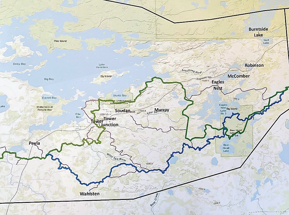
SOUDAN— Planners for the North Country National Scenic Trail are hoping to wrap up public comment on possible routes between Tower and Ely by the end of March, and they heard a strong vote of support from area residents here for a route that incorporates the Lake Vermilion state park and the growing network of trails located in Tower.
The North Country Trail (NCT) is one of just 11 Congressionally-authorized national hiking trails in the U.S. and it’s slated to be, by far, the longest once it’s eventually completed, stretching more than 5,000 miles from the Green Mountains of Vermont to central North Dakota.
More than 800 miles of the trail are planned for Minnesota, including much of the Arrowhead. The trail will incorporate some existing trails, when possible, but will also entail new construction as needed.
NCT staff are currently working with the Arrowhead Regional Development Commission to develop possible route corridors, using GIS mapping, as well as input from local trail enthusiasts, who are often the best source of information about existing trail resources. Local trail enthusiasts also typically make up a potential volunteer base for construction and ongoing maintenance of the NCT. Like other better-known national trails, like the Appalachian or Pacific Crest trails, the NCT will be built and maintained primarily by volunteers, according to Matt Davis, a staff member of the NCT, who was in Soudan last Thursday for a public meeting on the trail.
Using input from local residents and GIS mapping, ARDC has developed two possible routes that would connect from just southwest of Ely to the Pike River Flowage, about six miles west of Tower. To date, they have identified two possible route corridors, both of which go through Bear Head Lake State Park before taking distinctly different routes. The northerly route (Option A) would head north from Eagles Nest Township to Lake Vermilion’s Armstrong Bay before continuing west through the Lake Vermilion Soudan Underground Mine State Park and Tower before meeting back up with the southerly route near the Y Store. The southerly route (Option B) would head west from Bear Head Lake, eventually passing just north of the Wahlsten corner (Cty Rd. 26 and Hwy. 135) before heading northwest to intersect again with the northerly route.
The several local residents in attendance at the meeting all voiced support for the northerly route, which they noted includes many more sites of interest and would have available services for hikers, including campgrounds, restaurants, and stores in both Tower and Soudan. Davis said the ultimate route decision would be made by the National Park Service, which is charged with trail oversight, but Davis said the NPS typically relies on input from local residents on such decisions.
So far, Davis said about 3,100 miles of the trail have been built or designated, with about 2,000 miles yet to go, many of them in Minnesota. He said an 18-mile segment of the trail southwest of Grand Rapids is slated to be built later this year, by the NCT’s Arrowhead Chapter, which is based in Grand Rapids. That chapter is in charge of trail construction from Remer to Ely, noted Davis.
Currently, NCT hikers in the area are using the Mesabi Trail to connect with other portions of the trail, but NCT’s Davis said the national scenic trail system is supposed to be comprised, as much as possible, of simple, unpaved footpaths, in order to provide the best possible experience for hikers. The trail is required by law to be non-motorized, which prevents it from sharing trails used for motorized vehicles.
He said the NCT planners also try to avoid straight trails and will often deviate from the shortest possible route to bring hikers to areas of scenic interest. “We’re not looking for the shortest distance,” Davis said. “We’re looking for the best experience. We want people to always be wondering what’s around the next corner.”


