Support the Timberjay by making a donation.

Of unknown depth
Undocumented mine dates back to 1890s
LAKE VERMILION— St. Louis County officials plan to backfill a previously-undocumented iron ore mining operation located on Pine Island on Lake Vermilion, in order to reduce the potential risks to …
This item is available in full to subscribers.
Attention subscribers
To continue reading, you will need to either log in to your subscriber account, or purchase a new subscription.
If you are a current print subscriber, you can set up a free website account and connect your subscription to it by clicking here.
If you are a digital subscriber with an active, online-only subscription then you already have an account here. Just reset your password if you've not yet logged in to your account on this new site.
Otherwise, click here to view your options for subscribing.
Please log in to continue |
Of unknown depth
Undocumented mine dates back to 1890s

LAKE VERMILION— St. Louis County officials plan to backfill a previously-undocumented iron ore mining operation located on Pine Island on Lake Vermilion, in order to reduce the potential risks to the public.
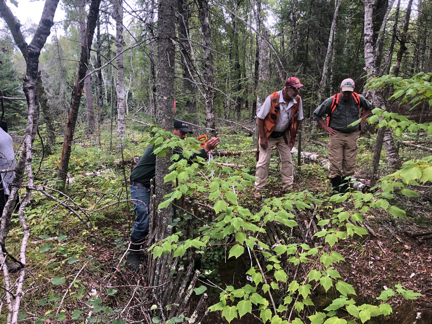
The former operation, which geologists believe dates back to the 1890s, is located on county tax-forfeit property about 300 feet from the island’s north shore, not far from Canfield Portage. The adjacent landowner, Wayne Dahl, had alerted St. Louis County land officials last year about what he thought at the time were merely exploration pits.
But after a site visit with county lands officials and geologists from both the Department of Natural Resources and the Natural Resources Research Institute in August, all involved realized that one of the pits is actually a mine shaft of unknown depth, excavated through bedrock.
The smaller of the two holes found at the site was similar to many test pits found throughout the region. According to Derek Harbin, a St. Louis County mine inspector who visited the site, the smaller pit measured approximately eight by 11 feet across, with a depth of about 12 feet.
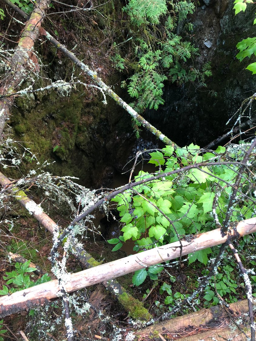
But the second hole, located nearby, was larger across, measuring 12 by 17 feet. “And we still don’t know how deep it is,” said Harbin. “It maxed out our tape measure at 100-plus feet.”
Water has risen in both pits, coming within 10 feet of the surface in the shallower pit and about 18 feet from the surface in the deeper pit.
A large nearby waste rock pile shows the operation removed a considerable amount of material, enough to convince geologists that the shaft also includes one or more drifts (or horizontal tunnels) most likely dug towards the north to gain access to an iron ore formation shown on geology maps of the island that date back to that era.
While such small-scale mining operations were hardly unusual in the region in the 1890s, NRRI geologist Dean Peterson said this one is interesting because there appears to be no records of the operation. “There is no record at all that we could find,” he said.
Peterson said it’s always fascinating to discover the exploration work that went on in the region during the early days of mining here. “History is a big part of geology. Seeing what the old timers did is pretty amazing.”
Some sheet metal remains found at the site suggest the miners may have used a steam-boiler to operate a drill. Wayne Dahl said it appears the boiler was about twice the size of a pot-bellied stove. He said he recalls, years ago, seeing a large number of snuff jars at the site as well, suggesting that the miners worked at the site for a considerable amount of time.
Dahl said nearby residents have known about the two pits for many years but didn’t realize that the one was actually a mine shaft. He said the pits had long been a kind of death trap for animals, including deer, and he remembers seeing and smelling rotting carcasses in the water in the pits. “Sometimes you could locate the pits by just following your nose,” he said.
The shallower pit does have the remains of an old snow fence that someone erected around it at some point, but the mine shaft itself appears to have never had any kind of protection.
Dahl said he is considering building a lake cabin on adjacent property and he now worries that the pits could prove a hazard for grandkids who might visit and explore in the nearby woods. He said the old mine shaft is only about 300 feet from his potential cabin site.
It’s that concern that prompted Dahl to contact county officials.
Now, county land officials are developing a plan to address the hazard. For now, the county has erected warning tape and notices around the pit and the shaft and they hope to have a permanent fix completed before ice-up. “Our primary interest is to safeguard the public,” said Harbin.
An initial plan to foam the entrance appears to have been rejected due to a high price tag. Now, said Harbin, the county is looking at having a loader barged to the island, in order to refill both the pit and the shaft with the waste rock remaining at the site. He estimates the cost at about $14,500.
Harbin said county officials recognized that the site could have some historical significance, which is why they alerted the two geologists. “We wanted to do our due diligence,” said Harbin. County officials originally suspected the mine could date back to the Vermilion gold rush era, in the late 1860s, but the geologists said it’s more likely the miners were looking to exploit the iron ore vein that runs through that portion of the island.
“It’s very intriguing,” said geologist Peterson. “And the size of the waste rock pile is pretty big.”
Peterson said the waste rock pile was exciting for a geologist to explore. “There were some very interesting rocks in there,” he said. “A lot of greenstone, schist, and iron formation. It was similar to what we see around Soudan. And there was some very rich jasper.”
Peterson said an interesting piece of local history is likely to be lost when the holes are refilled. “But then no one really knew about it,” he added.
Harbin said county officials do occasionally get reports of unusual holes in the ground, which usually turn out to be shallow test pits or some kind of natural subsidence. “We don’t run across things like this very often,” he said.
Addressing the hazard falls to St. Louis County because of the land’s tax-forfeit status. Were the land privately owned, the cost of mitigation would have likely fallen to the landowner.
Keywords
mine, lake vermilion, pine island


