Support the Timberjay by making a donation.

OUTLOOK UNCERTAIN
While el Niño brings milder conditions on average, effects are highly variable
REGIONAL— Seasonal weather forecasting here in the North Country is far from an exact science, and that goes double under an el Niño weather pattern like the one currently taking shape …
This item is available in full to subscribers.
Attention subscribers
To continue reading, you will need to either log in to your subscriber account, or purchase a new subscription.
If you are a current print subscriber, you can set up a free website account and connect your subscription to it by clicking here.
If you are a digital subscriber with an active, online-only subscription then you already have an account here. Just reset your password if you've not yet logged in to your account on this new site.
Otherwise, click here to view your options for subscribing.
Please log in to continue |
OUTLOOK UNCERTAIN
While el Niño brings milder conditions on average, effects are highly variable

REGIONAL— Seasonal weather forecasting here in the North Country is far from an exact science, and that goes double under an el Niño weather pattern like the one currently taking shape in the Pacific Ocean. That’s according to meteorologists with the National Weather Service office in Duluth, who spoke to area media about the upcoming winter’s weather during a Monday workshop.
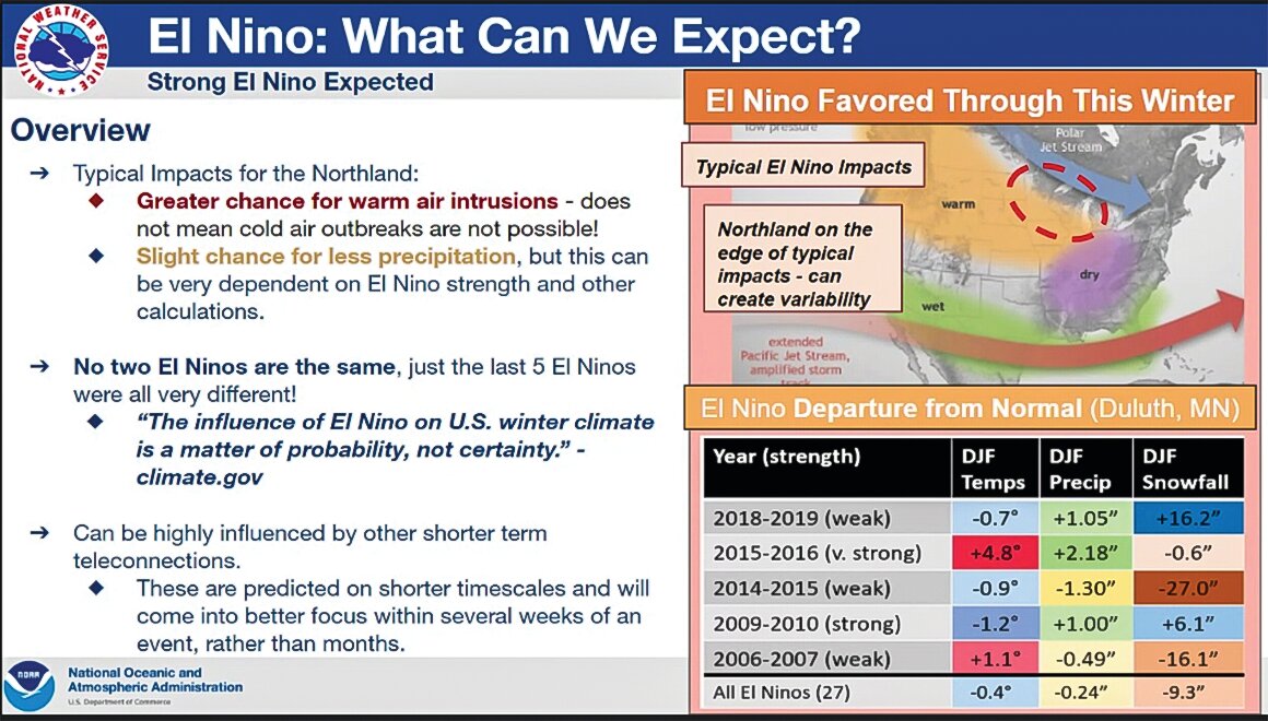
The el Niño is a warm upwelling in the eastern Pacific that typically affects winter weather across North America, how significantly is often dependent on the strength of the warming associated with the el Niño. This year’s el Niño is setting up to be a strong one, with a 30 percent chance that it will be classified as “very strong,” according to the NWS meteorologists.
While el Niños typically bring greater chances for warm air intrusions to the lower 48, the North Country is often close to the boundary between the warm air—which tends to dominate western North America during an el Niño— and the cooler air it typically brings to the northeastern U.S. And that means slight variations in temperatures and storm directions can make a big difference in the winter weather we actually experience here in northeastern Minnesota.
“No two el Niños are the same,” said Ketzel Levens, a meteorologist with the National Weather Service office in Duluth.
In general, said Levens, el Niño patterns create a slightly higher likelihood of a warmer and drier winter than average, although recent history has shown a remarkable degree of variability depending on the year.
The most recent el Niño, experienced in the winter of 2018-19, was categorized as weak, although its effects were quite pronounced, with significantly higher (16.2 inches above average) snowfall and an average Dec.-Feb. temperature that was 0.7 degrees colder than normal. The weak 2014-15 el Niño also brought slightly colder temperatures as well one of our driest winters in recent memory, with total snowfall a full 27 inches below normal. The lack of snowfall that winter prompted an outbreak of frozen water and sewer lines in many parts of the region.
By contrast, a very strong el Niño in 2015-16 brought an exceptionally warm and wet winter, even as total snowfall was below average since an almost unprecedented amount of precipitation fell as rain. The temperature for the Dec.-Feb. period averaged a whopping 4.8 degrees above average.
By contrast, the strong el Niño experienced in 2009-10 brought colder than average temperatures and slightly above-average snowfall.
The National Weather Service’s Climate Prediction Center is betting on a warmer and drier winter for much of the northern tier of the U.S., with its Dec.-Feb. forecast showing a strong likelihood of above normal temperatures and a less pronounced chance of below normal precipitation.
Levens noted, however, that such long-term forecasts are based on probabilities and are far from certainties. When it comes to el Niños in northeastern Minnesota, the impacts are highly variable.
Communicating
to the public
Whatever winter weather arrives in the coming weeks and months, the public can turn to www.weather.gov/dlh/weatherstory at any time of day for the most up-to-date information on upcoming weather in northeastern Minnesota. During severe winter weather, the forecasts are refined and updated every few hours, typically with detailed maps and timelines showing the extent and timing of the expected weather impacts.


