Support the Timberjay by making a donation.

USDA climate map shows major warming in the state
Zone 4 now extends to the Mesabi Iron Range; Twin Cities in Zone 5
REGIONAL— The effects of climate change are, once again, apparent in the latest plant hardiness zone map update put out by the U.S. Department of Agriculture. The hardiness map is used by plant …
This item is available in full to subscribers.
Attention subscribers
To continue reading, you will need to either log in to your subscriber account, or purchase a new subscription.
If you are a current print subscriber, you can set up a free website account and connect your subscription to it by clicking here.
If you are a digital subscriber with an active, online-only subscription then you already have an account here. Just reset your password if you've not yet logged in to your account on this new site.
Otherwise, click here to view your options for subscribing.
Please log in to continue |
USDA climate map shows major warming in the state
Zone 4 now extends to the Mesabi Iron Range; Twin Cities in Zone 5
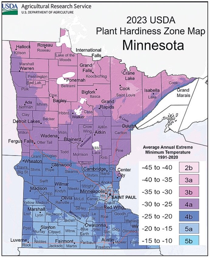
REGIONAL— The effects of climate change are, once again, apparent in the latest plant hardiness zone map update put out by the U.S. Department of Agriculture.
The hardiness map is used by plant growers to help guide their selections of perennial plants, such as fruit and ornamental trees, shrubs, and flowers. The zone designations, which range from 1a to 13b, are based on the annual minimum temperatures experienced within the zone.
It’s updated by the USDA periodically and it has provided a highly accurate portrait of the warming climate in recent decades as the zones have marched steadily northward.
The 2023 map, released this past week, again shows major changes across Minnesota, including here in the North Country.
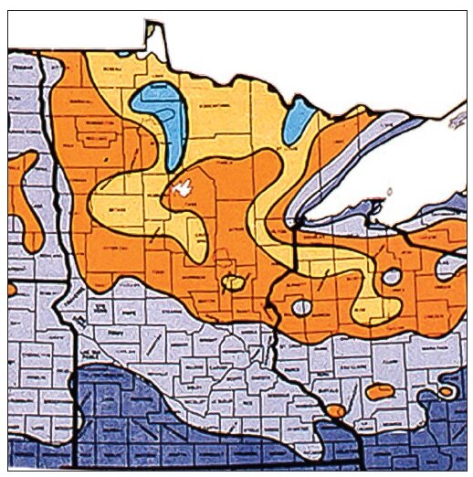
As recently as 1990, the vast majority of St. Louis and Koochiching counties were listed as Zone 3a, which reflects an annual minimum temperature of minus 35-40 degrees F. Much of northeastern St. Louis County, including Tower, Ely, and Embarrass, were listed as Zone 2b, reflecting an annual average minimum of minus 40-45 F. Most of central Minnesota was classified as Zone 3b, a designation that extended as far south as the northern suburbs of the Twin Cities and reflected annual average annual minimum temperatures of minus 30-35 F.
By 2012, Zone 3 had retreated to the northern half of the state and a few pockets in the southernmost counties of the state were designated as Zone 5a for the first time, reflecting annual minimums of minus 15-20 F.
The map released last week, by contrast, shows Zone 3a, which used to cover a huge swath of northern Minnesota back in 1990, was reduced to two small pockets centered over Tower and Embarrass and the far northern edge of Koochiching County, while Zone 4a now encompasses the entire Mesabi Iron Range. Zone 3b, reflecting annual minimums of minus 30-35 F, has retreated to the northern third of Minnesota east of the Red River valley.
Much of southern Minnesota and the entire Twin Cities metropolitan area is now classified as Zone 5a, a zone that didn’t exist within 100 miles of Minnesota as recently as 1990.
“It’s a big change,” said Pete Boulay, state climatologist.
The disappearance of the Zone 3 designation in the Lower 48 states has been among the most dramatic changes in the past 30 years. In 1990, Zone 3a or 3b classification extended across the northern half of Minnesota and North Dakota, northeastern Montana, the northern third of Maine and in pockets of the intermountain West and higher elevations of New England.
Today, Zone 3 is limited mostly to northern Minnesota, with smaller pockets along the Canadian border in North Dakota and Montana. Today, the only Zone 3a designation remaining in the Lower 48 is found in pockets of St. Louis and Koochiching counties in Minnesota, and a tiny pocket at high elevation near the Idaho-Montana border. If current trends continue, it is a designation almost certain to vanish in the Lower 48 with the USDA’s next update.
“You don’t get to minus 40 like you used to up north,” said Boulay.


