Support the Timberjay by making a donation.

Blending low-tech legwork, high-tech labwork
COOK- The gathering at Cook’s Country Connection on Thursday, Oct. 6 to talk about sedimentation in the Little Fork River might best be described as an environmental version of “preaching to the choir,” as nearly everyone who attended seemed to have some connection to one of the departments or agencies involved with the measurement and remediation project. That didn’t dampen the enthusiasm of the day’s primary presenter, Minnesota Pollution Control Agency Project Coordinator Mike Jackson, a man skilled at translating scientific terms and data into easily-understood morsels spiced with liberal doses of entertaining humor. It was humor that came through in his opening observation about the event. “I don’t know what’s better, going to a public meeting where there’s all kinds of crazy problems and the room is packed, or going to a public meeting where there’s six people and there’s no problems to talk about,” he mused. “It’s kind of either or in my world. Sometimes I end up in a packed gymnasium and get screamed at, or I get a lot of interesting questions.” The problem The 160-mile Little Fork River begins at Lost Lake, about six miles due west of Tower, and winds a sinuous path through St. Louis, Koochiching and Itasca counties to its confluence with the Rainy River. The broader 1.2-million-acre Little Fork River Watershed is sparsely inhabited, and the waters flowing through it into the Little Fork River have been described as “some of the most pristine and remote waters in the State of Minnesota.” Pristine seems less accurate for portions of the Little Fork itself, given the amount of suspended sediment particulates in the river that Jackson said is four times more than the established federal threshold. “About 144 miles have too much sediment in the river,” Jackson said. Elevated sediment levels impact the fragile balance of ecological environments for fish, plants, and microbes all along those 144 miles. In highly populated industrial regions, water pollution is mostly attributable to human activity, but in the Little Fork Watershed, the sediment problem is believed to be mostly natural, with logging having been identified as a contributing factor over the years. Another problem is that the sediment also has elevated levels of phosphorous. With the waters of the Little Fork eventually ending up in the Lake of the Woods, the Little Fork is the largest contributor of phosphorous in the entire Rainy-Lake of the Woods basin, a contribution that aids in fueling large green algae blooms. “Lake of the Woods is blooming like pea soup,” Jackson said. “Why? Phosphorus.” An eyeball examination provides clues, but to confirm where all the sediment is coming from. MPCA is collaborating with soil and water conservation districts in St. Louis, Itasca, and Koochiching counties and with the U.S. Geological Survey to conduct a sediment fingerprinting project. Getting samples The basic premise of the study is simple. Collects soil samples from land along the length of the Little Fork River, collect “buckets and gallons” of water samples at strategic locations in the river, and distill the samples down with the hope that the process ends up with, as Jackson said, “about ten sugar cubes (of sediment) to do the lab work.” USGS will do the lab work, developing unique detailed chemical “fingerprints” for every sample of land and water-borne sediment. When land and sediment fingerprints match, the source of that sediment has been determined. “It’s always exciting to get ‘rocket scientists’ to do stuff in your watershed,” Jackson said. It’s seemingly simple, but the actual process of collecting the sediment samples has been anything but. The extreme drought of 2021 caused the second-lowest flowage in the recorded history of the Little Fork, making comprehensive collections impossible. Investigators practiced sampling where they could as they waited for better conditions this year. What they got instead was record-breaking flooding. Accuracy depends on sampling the river at flows as close to normal as possible, and with sampling tubes submerged under several feet of excess water for weeks, another delay was encountered. But as the water levels receded, sampling resumed in earnest, and the final samples have now been collected. Remediation Jackson said he anticipates that the USGS will complete its lab work far ahead of schedule. “We think we’re gonna get results a lot sooner than we anticipated,” he said. “I was thinking, knowing the federal government, we would see nothing until next year by the Fourth of July. But I don’t think so. I think within a month.” With the fingerprinting results in hand, planners can begin developing the multi-year strategies and projects that will bring the sediment levels in the river down closer to acceptable levels. Jackson made a guess that there could be $200-350 thousand annually from the state for projects. “Your list of items to do is going to be 20 to 40 items long. You’re probably only going to be able to do two or three of them a year," he said. Jackson said additional public meetings will be scheduled when the results of the sediment fingerprinting are available.
COOK- The gathering at Cook’s Country Connection on Thursday, Oct. 6 to talk about sedimentation in the Little Fork River might best be described as an environmental version of “preaching …
This item is available in full to subscribers.
Attention subscribers
To continue reading, you will need to either log in to your subscriber account, or purchase a new subscription.
If you are a current print subscriber, you can set up a free website account and connect your subscription to it by clicking here.
If you are a digital subscriber with an active, online-only subscription then you already have an account here. Just reset your password if you've not yet logged in to your account on this new site.
Otherwise, click here to view your options for subscribing.
Please log in to continue |
Blending low-tech legwork, high-tech labwork
COOK- The gathering at Cook’s Country Connection on Thursday, Oct. 6 to talk about sedimentation in the Little Fork River might best be described as an environmental version of “preaching to the choir,” as nearly everyone who attended seemed to have some connection to one of the departments or agencies involved with the measurement and remediation project. That didn’t dampen the enthusiasm of the day’s primary presenter, Minnesota Pollution Control Agency Project Coordinator Mike Jackson, a man skilled at translating scientific terms and data into easily-understood morsels spiced with liberal doses of entertaining humor. It was humor that came through in his opening observation about the event. “I don’t know what’s better, going to a public meeting where there’s all kinds of crazy problems and the room is packed, or going to a public meeting where there’s six people and there’s no problems to talk about,” he mused. “It’s kind of either or in my world. Sometimes I end up in a packed gymnasium and get screamed at, or I get a lot of interesting questions.” The problem The 160-mile Little Fork River begins at Lost Lake, about six miles due west of Tower, and winds a sinuous path through St. Louis, Koochiching and Itasca counties to its confluence with the Rainy River. The broader 1.2-million-acre Little Fork River Watershed is sparsely inhabited, and the waters flowing through it into the Little Fork River have been described as “some of the most pristine and remote waters in the State of Minnesota.” Pristine seems less accurate for portions of the Little Fork itself, given the amount of suspended sediment particulates in the river that Jackson said is four times more than the established federal threshold. “About 144 miles have too much sediment in the river,” Jackson said. Elevated sediment levels impact the fragile balance of ecological environments for fish, plants, and microbes all along those 144 miles. In highly populated industrial regions, water pollution is mostly attributable to human activity, but in the Little Fork Watershed, the sediment problem is believed to be mostly natural, with logging having been identified as a contributing factor over the years. Another problem is that the sediment also has elevated levels of phosphorous. With the waters of the Little Fork eventually ending up in the Lake of the Woods, the Little Fork is the largest contributor of phosphorous in the entire Rainy-Lake of the Woods basin, a contribution that aids in fueling large green algae blooms. “Lake of the Woods is blooming like pea soup,” Jackson said. “Why? Phosphorus.” An eyeball examination provides clues, but to confirm where all the sediment is coming from. MPCA is collaborating with soil and water conservation districts in St. Louis, Itasca, and Koochiching counties and with the U.S. Geological Survey to conduct a sediment fingerprinting project. Getting samples The basic premise of the study is simple. Collects soil samples from land along the length of the Little Fork River, collect “buckets and gallons” of water samples at strategic locations in the river, and distill the samples down with the hope that the process ends up with, as Jackson said, “about ten sugar cubes (of sediment) to do the lab work.” USGS will do the lab work, developing unique detailed chemical “fingerprints” for every sample of land and water-borne sediment. When land and sediment fingerprints match, the source of that sediment has been determined. “It’s always exciting to get ‘rocket scientists’ to do stuff in your watershed,” Jackson said. It’s seemingly simple, but the actual process of collecting the sediment samples has been anything but. The extreme drought of 2021 caused the second-lowest flowage in the recorded history of the Little Fork, making comprehensive collections impossible. Investigators practiced sampling where they could as they waited for better conditions this year. What they got instead was record-breaking flooding. Accuracy depends on sampling the river at flows as close to normal as possible, and with sampling tubes submerged under several feet of excess water for weeks, another delay was encountered. But as the water levels receded, sampling resumed in earnest, and the final samples have now been collected. Remediation Jackson said he anticipates that the USGS will complete its lab work far ahead of schedule. “We think we’re gonna get results a lot sooner than we anticipated,” he said. “I was thinking, knowing the federal government, we would see nothing until next year by the Fourth of July. But I don’t think so. I think within a month.” With the fingerprinting results in hand, planners can begin developing the multi-year strategies and projects that will bring the sediment levels in the river down closer to acceptable levels. Jackson made a guess that there could be $200-350 thousand annually from the state for projects. “Your list of items to do is going to be 20 to 40 items long. You’re probably only going to be able to do two or three of them a year," he said. Jackson said additional public meetings will be scheduled when the results of the sediment fingerprinting are available.
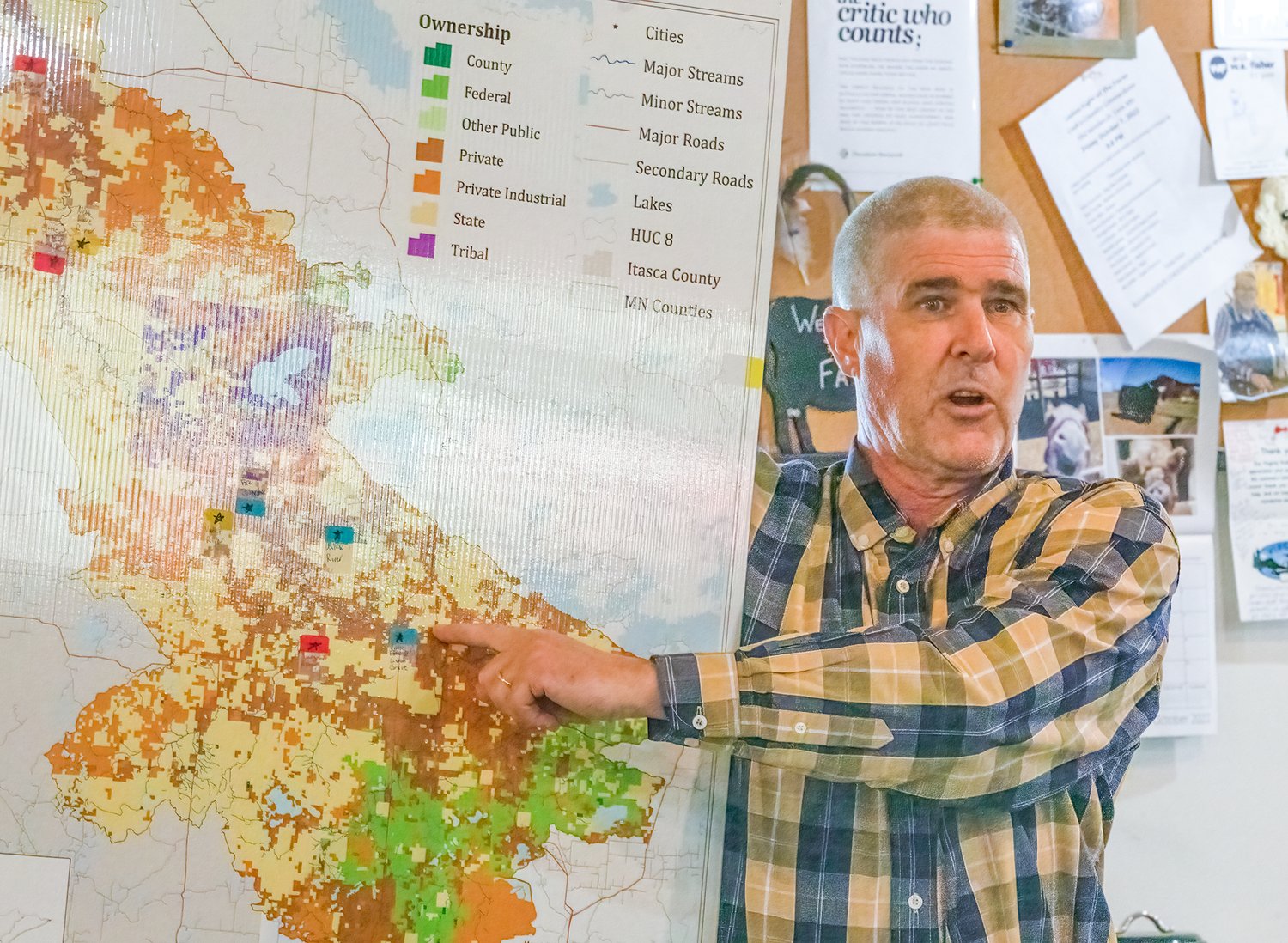
COOK- The gathering at Cook’s Country Connection on Thursday, Oct. 6 to talk about sedimentation in the Little Fork River might best be described as an environmental version of “preaching to the choir,” as nearly everyone who attended seemed to have some connection to one of the departments or agencies involved with the measurement and remediation project.
That didn’t dampen the enthusiasm of the day’s primary presenter, Minnesota Pollution Control Agency Project Coordinator Mike Jackson, a man skilled at translating scientific terms and data into easily-understood morsels spiced with liberal doses of entertaining humor. It was humor that came through in his opening observation about the event.
“I don’t know what’s better, going to a public meeting where there’s all kinds of crazy problems and the room is packed, or going to a public meeting where there’s six people and there’s no problems to talk about,” he mused. “It’s kind of either or in my world. Sometimes I end up in a packed gymnasium and get screamed at, or I get a lot of interesting questions.”
The problem
The 160-mile Little Fork River begins at Lost Lake, about six miles due west of Tower, and winds a sinuous path through St. Louis, Koochiching and Itasca counties to its confluence with the Rainy River. The broader 1.2-million-acre Little Fork River Watershed is sparsely inhabited, and the waters flowing through it into the Little Fork River have been described as “some of the most pristine and remote waters in the State of Minnesota.”
Pristine seems less accurate for portions of the Little Fork itself, given the amount of suspended sediment particulates in the river that Jackson said is four times more than the established federal threshold.
“About 144 miles have too much sediment in the river,” Jackson said.
Elevated sediment levels impact the fragile balance of ecological environments for fish, plants, and microbes all along those 144 miles. In highly populated industrial regions, water pollution is mostly attributable to human activity, but in the Little Fork Watershed, the sediment problem is believed to be mostly natural, with logging having been identified as a contributing factor over the years.
Another problem is that the sediment also has elevated levels of phosphorous. With the waters of the Little Fork eventually ending up in the Lake of the Woods, the Little Fork is the largest contributor of phosphorous in the entire Rainy-Lake of the Woods basin, a contribution that aids in fueling large green algae blooms.
“Lake of the Woods is blooming like pea soup,” Jackson said. “Why? Phosphorus.”
An eyeball examination provides clues, but to confirm where all the sediment is coming from. MPCA is collaborating with soil and water conservation districts in St. Louis, Itasca, and Koochiching counties and with the U.S. Geological Survey to conduct a sediment fingerprinting project.
Getting samples
The basic premise of the study is simple. Collects soil samples from land along the length of the Little Fork River, collect “buckets and gallons” of water samples at strategic locations in the river, and distill the samples down with the hope that the process ends up with, as Jackson said, “about ten sugar cubes (of sediment) to do the lab work.”
USGS will do the lab work, developing unique detailed chemical “fingerprints” for every sample of land and water-borne sediment. When land and sediment fingerprints match, the source of that sediment has been determined.
“It’s always exciting to get ‘rocket scientists’ to do stuff in your watershed,” Jackson said.
It’s seemingly simple, but the actual process of collecting the sediment samples has been anything but. The extreme drought of 2021 caused the second-lowest flowage in the recorded history of the Little Fork, making comprehensive collections impossible. Investigators practiced sampling where they could as they waited for better conditions this year.
What they got instead was record-breaking flooding. Accuracy depends on sampling the river at flows as close to normal as possible, and with sampling tubes submerged under several feet of excess water for weeks, another delay was encountered. But as the water levels receded, sampling resumed in earnest, and the final samples have now been collected.
Remediation
Jackson said he anticipates that the USGS will complete its lab work far ahead of schedule.
“We think we’re gonna get results a lot sooner than we anticipated,” he said. “I was thinking, knowing the federal government, we would see nothing until next year by the Fourth of July. But I don’t think so. I think within a month.”
With the fingerprinting results in hand, planners can begin developing the multi-year strategies and projects that will bring the sediment levels in the river down closer to acceptable levels. Jackson made a guess that there could be $200-350 thousand annually from the state for projects.
“Your list of items to do is going to be 20 to 40 items long. You’re probably only going to be able to do two or three of them a year," he said.
Jackson said additional public meetings will be scheduled when the results of the sediment fingerprinting are available.


