Support the Timberjay by making a donation.

Fire danger remains relatively high for June
REGIONAL— June is typically one of northern Minnesota’s wettest month, but that hasn’t proven to be the case so far this year— and that has helped elevate fire danger across virtually all of …
This item is available in full to subscribers.
Attention subscribers
To continue reading, you will need to either log in to your subscriber account, or purchase a new subscription.
If you are a current print subscriber, you can set up a free website account and connect your subscription to it by clicking here.
If you are a digital subscriber with an active, online-only subscription then you already have an account here. Just reset your password if you've not yet logged in to your account on this new site.
Otherwise, click here to view your options for subscribing.
Please log in to continue |
Fire danger remains relatively high for June
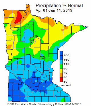
REGIONAL— June is typically one of northern Minnesota’s wettest month, but that hasn’t proven to be the case so far this year— and that has helped elevate fire danger across virtually all of northern Minnesota. Indeed, high winds and warm temperatures this past weekend prompted the National Weather Service to issue a critical fire danger advisory on June 8.
No serious fires were reported over the weekend, although fire crews did extinguish an eight-acre wildfire near Gunsten Lake, located about two miles northeast of the junction of Hwy. 1 and Hwy. 2, in Lake County. That fire was reported by aerial reconnaissance.
Spring fire danger typically all but vanishes once the fields and forests green up in the North Country, but the lack of normal rainfall has kept fire dangers elevated well into June this year.
While limited showers have stemmed the danger at times in recent weeks, until more consistent rainfall arrives, the risk of wildfire is likely to continue. With generally dry and sunny weather forecast into the weekend, there’s little sign of a break in the pattern.
Much of northwestern Minnesota is already listed as “abnormally dry” by the U.S. Drought Monitor and with precipitation running below normal across northeastern Minnesota over the past six weeks, it appears that the area experiencing the early stages of drought could well expand.
Since May 1, every reporting station in northeastern Minnesota north of Duluth or Two Harbors is running below average for precipitation. Some reporting stations, like Babbitt, Orr, and a station located 25 miles east of Ely have received barely half of their normal precipitation since May 1. Many others, including Tower, Cook, and Embarrass, are also running well-below average.
“In northern Minnesota, you should be getting roughly an inch of rain a week, so things can quickly fall behind,” said state climatologist Pete Boulay. Northern Minnesota normally receives almost 60 percent of its total annual precipitation in the four months from June 1-Sept. 30. In a normal year, northern St. Louis and Lake counties average 26-29 inches of total precipitation.
Extended prescribed fire season
The dry weather has offered a silver lining to fire crews hoping to make progress on a long list of prescribed fire treatments in the Superior National Forest. Fire crews have successfully treated a total of more than 3,600 acres on approximately a dozen units with prescribed fire, including dead vegetation that had been piled for burning. “This is good news for native plants and wildlife who depend on fire to create conditions for them to thrive, good for general forest health and regeneration, and good in terms of reduced wildfire hazards for people living near or visiting the forest,” stated the Forest Service in a press statement issued late last week.
This large amount of prescribed fire work was accomplished by Superior National Forest personnel with the assistance of fire crews from several different national forests and other federal agencies. Operations involved crews on the ground and in boats on the water with air support from planes and helicopters.
As favorable conditions continue, crews plan to complete additional prescribed fires and are also prepared to respond to wildfires.


