Support the Timberjay by making a donation.

Mixed news in latest flood outlook
REGIONAL— The National Weather Service office in Duluth is offering both good news and bad news on the prospect for spring flooding in the North Country. Exceptional amounts of snow have fallen …
This item is available in full to subscribers.
Attention subscribers
To continue reading, you will need to either log in to your subscriber account, or purchase a new subscription.
If you are a current print subscriber, you can set up a free website account and connect your subscription to it by clicking here.
If you are a digital subscriber with an active, online-only subscription then you already have an account here. Just reset your password if you've not yet logged in to your account on this new site.
Otherwise, click here to view your options for subscribing.
Please log in to continue |
Mixed news in latest flood outlook
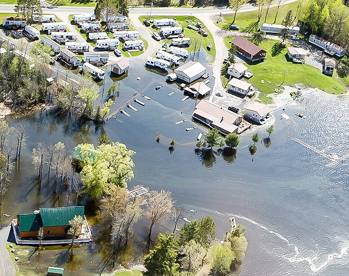
REGIONAL— The National Weather Service office in Duluth is offering both good news and bad news on the prospect for spring flooding in the North Country.
Exceptional amounts of snow have fallen across much of northeastern Minnesota in recent weeks, substantially raising the flood risk come April and May. That’s the bad news. The good news is that much of that recent additional snow has fallen in the southern half of the Arrowhead, which means runoff from the eventual spring melt won’t necessarily impact the Rainy River watershed, which experienced the worst flooding in the modern historical record last spring.
In an online briefing held March 10, National Weather Service meteorologist Ketzel Levens said the current circumstances in the Rainy River basin suggest a lower risk of the kind of flooding experienced last year. Levens said the snow/water equivalent, or SWE, in the current snowpack is about one to two inches lower than at this same time last year. Levens made her comment, however, before this past weekend’s snow event, which left several more inches of fresh snow on the ground throughout the watershed. A second storm was forecasted to drop even more snow on the area Thursday and Friday, after the Timberjay’s Wednesday deadline, which was expected to further add to the moisture content in the snowpack.
Throughout northern St. Louis and Koochiching counties the SWE was only slightly above the historical average as of Leven’s March 10 briefing, varying from just over three inches in parts of Koochiching and far northwestern St. Louis County to about five inches in central portions of the watershed. The snowpack in the eastern portion of the watershed does contain substantially more water, as much as seven inches or more, which is well above the historical average for this time of year.
Watersheds feeding into Lake Superior or the Mississippi headwaters region are running closer to historical records for SWE, according to Levens, and that has substantially elevated the spring flooding risk in these areas. The Mississippi River, near Aitkin, has a better than 95 percent chance of minor flooding this spring, an 84 percent chance of moderate flooding, and a 28 percent chance of a major flood event.
Such risks diminish to the far north, where snowfall has been much closer to average. The lack of frost in the ground, due to the thick snowpack and mild temperatures this winter, should also help allow some meltwater to soak into the soil, according to Levens, which has the effect of reducing flooding. At the same time, she notes that the soil moisture was relatively high coming into winter, which may reduce the soil’s ability to absorb meltwaters.
“The current setup for flooding is somewhat less than last year [within the Rainy River watershed], but there is still considerable uncertainty,” said Levens. “We don’t know what April or May will bring,” she said.
While the amount of water in the snowpack is a significant factor, it is only one of several that determine the risk of flooding. She said additional snow or rain added to the snowpack between now and the end of the snowmelt and the timing and speed of the melt are key unknowns going forward. At least through the month of March, the current weather outlook calls for seasonable-to-slightly below average temperatures through the end of March. That’s likely to push any substantial snowmelt off into April, notes Leven, which increases the risks of flooding. “The further into the spring we go without losing the snowpack, the higher the risk of rain events that could substantially worsen the situation,” she said.
The National Weather Service plans to issue its fourth and final spring flooding outlook on Thursday, March 23.


