Support the Timberjay by making a donation.

Much of BWCAW closed
Multiple Quetico fires potentially threaten area from Basswood to Crane; progress made on Delta Lake fire
REGIONAL— The U.S. Forest Service has closed a significant portion of the Boundary Waters Canoe Area Wilderness due to the threat posed by a half dozen wildfires burning in Quetico Provincial …
This item is available in full to subscribers.
Attention subscribers
To continue reading, you will need to either log in to your subscriber account, or purchase a new subscription.
If you are a current print subscriber, you can set up a free website account and connect your subscription to it by clicking here.
If you are a digital subscriber with an active, online-only subscription then you already have an account here. Just reset your password if you've not yet logged in to your account on this new site.
Otherwise, click here to view your options for subscribing.
Please log in to continue |
Much of BWCAW closed
Multiple Quetico fires potentially threaten area from Basswood to Crane; progress made on Delta Lake fire

REGIONAL— The U.S. Forest Service has closed a significant portion of the Boundary Waters Canoe Area Wilderness due to the threat posed by a half dozen wildfires burning in Quetico Provincial Park, just north of the border.
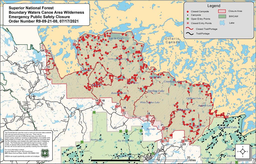
The closed area includes all of the northwestern-most portion of the wilderness area, stretching from just west of Basswood Lake, near Ely, west to Crane Lake. According to Forest Service officials, those fires have become more active in recent days and have the potential to spread to the U.S. side of the border, where they could pose a danger to canoeists in the area as well as potential rescuers. The closure includes all lakes, entry points, portages, and campsites located within the closed area.
The closures went into effect in two stages, with an initial closure that began last Saturday that focused on routes to Crooked Lake. The second much larger closure took effect last Sunday and included a roughly thirty-mile stretch of the border country north and west of Ely. That closure will remain in place at least until July 25, and comes on top of the Delta Lake closures enacted earlier this month. In addition, the Forest Service has enacted burning restrictions across the Superior National Forest, including the BWCAW, as drought conditions intensify in the region. Temperatures across the area have been running well above normal this summer, while rainfall has been far below average in recent months, leaving forests tinder dry. “We’ve been using the word ‘historic’ to describe the conditions,” said Aaron Kania, district ranger on the Superior’s Kawishiwi District. “We’d have to go back to the early 1970s to find something similar,” he added.
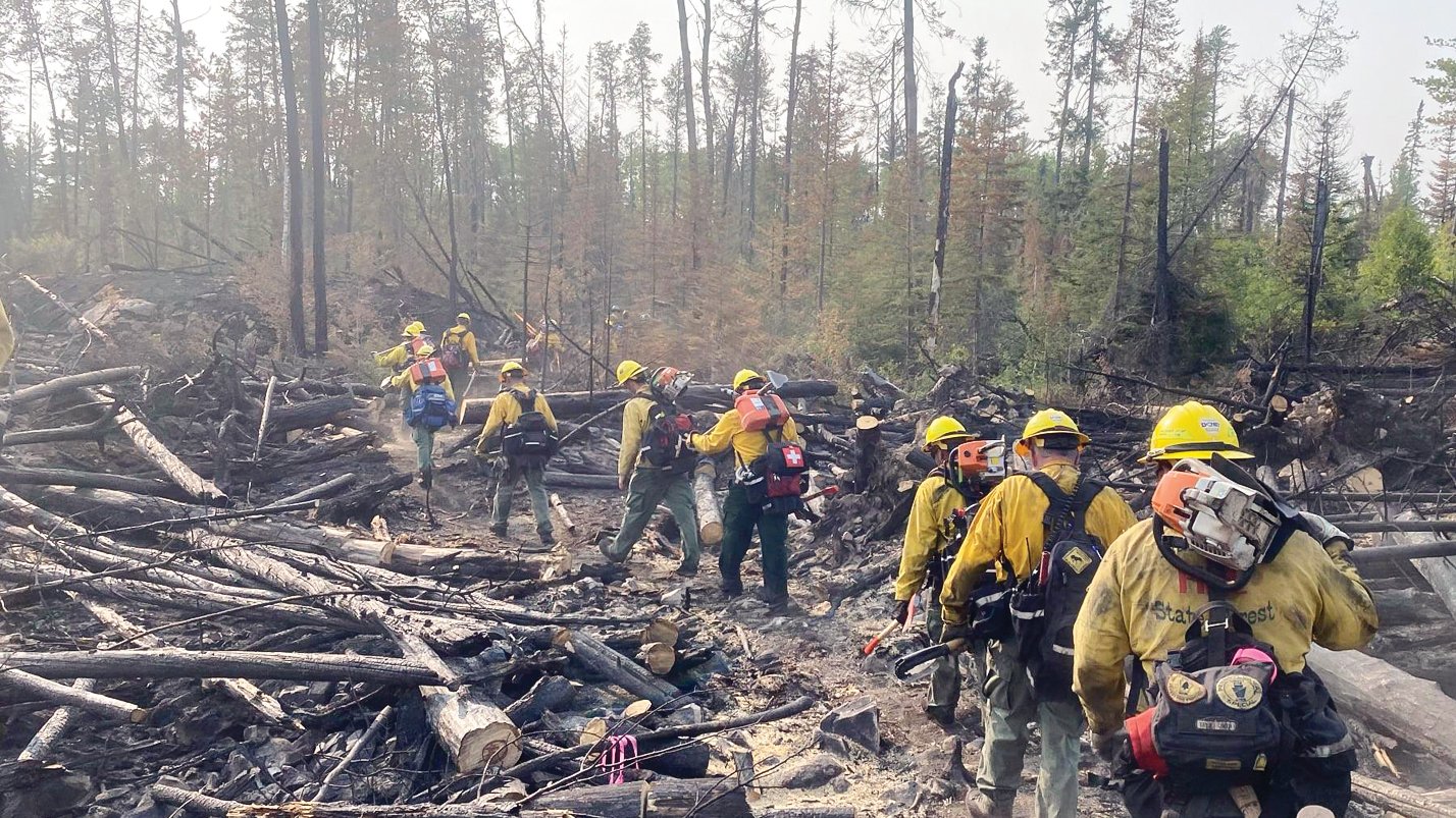
So far, firefighters have been aided by generally light winds, but there is no guarantee that those conditions will continue, which is why Forest Service officials have opted for caution with the closures in the northwestern part of the wilderness. “Travel times to these areas in the BWCAW are measured in days, not hours, and this would not allow for rapid evacuation of the area,” stated the Forest Service in a statement issued this week. Forest Service officials note that it can take considerable time to locate wilderness travelers in the event they might need to evacuate from an active fire. Several Forest Service employees nearly died a decade ago while warning canoeists to evacuate ahead of the 2011 Pagami Creek fire, which torched about 92,000 acres southeast of Ely.
Kania said forest officials opted to give wilderness travelers plenty of notice of the closure so they could evacuate without feeling rushed. Wilderness rangers began alerting canoeists of the closures late last week and expanded their efforts with the latest closure order.
At least seven fires are currently burning within the Quetico Provincial Park, including a new one reported in the wake of a thunderstorm that passed through the area on Monday. Three of those fires are located just north of the border. The largest, centered near Ted Lake, had scorched 4,892 acres as of Tuesday morning, according to Quetico park officials. The Crooked Lake fire, which began earlier this month on the Canadian side of the border lake, had scorched 4,447 acres, while a third fire, near McIntyre Lake had burned 2,261 acres. Combined, the seven fires currently burning in the park have scorched more than 16,000 acres. Those fires are among nearly 120 currently burning in northwestern Ontario, which have contributed to days of smoky conditions across northern Minnesota.
Given the remote location of the Quetico fires, along with a number of higher priority fires in the province, Canadian officials are conducting aerial reconnaissance of the fires, but are not actively seeking to control them. Quetico Superintendent Trevor Gibb said Monday’s line of thunderstorms brought variable amounts of rain to the park, but nowhere near enough to significantly impact fire danger in the area.
Like their American counterparts, Quetico officials have instituted their own closure across a wide swath of the southwestern portion of the 1.2 million-acre park, from roughly Agnes Lake in the east to Lac La Croix in the west.
Outfitters impacted
While the closures in the Boundary Waters were instituted for safety, they’ve left Ely area outfitters scrambling to accommodate clients whose permits for trips into the affected areas have been canceled.
Ely outfitter Jason Zabokrtsky said his staff had been able to manage the more limited closures from the Delta fire and the Crooked Lake fire that had been announced late last week. “With the dramatic closure of such a large area, however, we just don’t have good options for redirecting people,” he said.
Finding alternatives has been made even harder by the fact that virtually every Boundary Waters permit has already been reserved for many peak periods this summer. While that’s not unusual for those seeking the very limited number of motorized permits, Zabokrtsky said this year is the first time that he’s seen days when no canoe permits are available. “It’s a shocking thing to look at the reservation site and see all zeros,” he said.
The shortage of permits points to the sharp increase in interest in visiting the BWCAW since the COVID-19 pandemic. Zabokrtsky said his business was booming, at least until the closure hit. Now, given the lack of permits and the uncertainty created by the fires, he’s seeing a significant number of trip cancellations. “We were on track to have our busiest season ever, but based on the cancellations I’m seeing, I don’t know that that’s going to be the case,” he said. The final results will depend on how long the closures last, but Zabokrtsky isn’t optimistic given the weather so far this summer. “My thoughts are that we may be dealing with this until the snow flies,” he said.
Ely outfitter Steve Piragis agrees that the closure could remain in effect for some time, and that it’s likely to affect the bottom line. The good news, however, is that Piragis’s company was already having an exceptional year so they’ll likely weather this new bump in the road.
Ely has been packed with summer visitors in recent weeks and Piragis, who runs a retail store in addition to his outfitting business, said sales have been the best ever this year.
But Piragis is more concerned with the long-term outlook. “This may be an indication that climate change is finally catching up with us,” he said, noting that the summer has been exceptionally hot and dry all across the western half of North America. While Piragis said he remembers one previous Boundary Waters closure years ago, he said that was in September, which is frequently a period of higher fire danger in northeastern Minnesota. “We’ve never had fire conditions like this in mid-summer,” he said, and he’s concerned the fire situation could still get significantly worse.
Zabokrtsky agrees and said that’s one reason he’s not second-guessing the Forest Service’s decision to close such a broad stretch of the Boundary Waters. “These are really significant fires, and conditions are such that they have to take really significant precautions,” he said.
Considering options
While the Quetico fires have, so far, remained north of the border, the growth in the fires in recent days has created large fire fronts that could easily explode during the next windy, dry day, as the Pagami Creek fire demonstrated in 2011. That prospect prompted Forest Service officials to reach out early on to Canadian authorities in an effort to coordinate monitoring and contingency planning, assuming the fires continue to grow.
“We have a crew up there assessing the area, if and when it does cross the border,” said Joanna Gilkerson, chief information officer for the Superior. For now, at least, U.S. firefighters will be confining their activities to the U.S. side, said Gilkerson.


