Support the Timberjay by making a donation.

Dry conditions continue to worsen
Parts of St. Louis County and most of Lake County now in moderate drought
REGIONAL— Drought conditions continue to build across Minnesota, including here in the North Country, despite some recent rains. That’s according to the National Weather Service Office in …
This item is available in full to subscribers.
Attention subscribers
To continue reading, you will need to either log in to your subscriber account, below, or purchase a new subscription.
Please log in to continue |
Dry conditions continue to worsen
Parts of St. Louis County and most of Lake County now in moderate drought
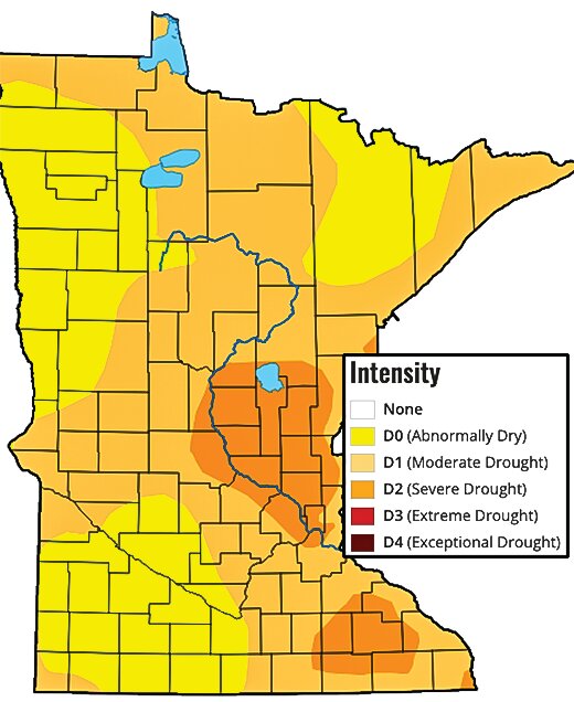
REGIONAL— Drought conditions continue to build across Minnesota, including here in the North Country, despite some recent rains. That’s according to the National Weather Service Office in Duluth as well as the U.S. Drought Monitor. The latest weekly drought monitor shows all of Minnesota and the vast majority of the Upper Midwest in varying levels of drought.
Most of northern Minnesota is now in moderate drought, although most of the northern two-thirds of St. Louis County are listed as abnormally dry, which is the lowest level of drought status. Only far western and far southern St. Louis County are currently listed in moderate drought, along with most of Lake and Cook counties.
Despite a very wet winter and early spring, the region’s weather pattern flipped to a dry one in May and much of June - which would normally be one of the wettest periods of the year. While the region received significant rains at the end of June and some modest rains since then, the area continues to fall behind during a period of the year when average rainfall typically runs between 1 and 1.5-inches per month. Cooler weather in July has likely helped reduce the effects of the more limited rainfall.
According to the National Weather Service (NWS), long term outlooks for the rest of the summer suggest above-average temperatures and average-to-below-average precipitation, which is expected to further exacerbate drought conditions.
Water levels dropping
The effects of the drought are showing up in river levels in the region, as rivers across the region have been dropping to close to Q90 levels, which indicates a river that’s in the bottom 10th percentile or lower for flow. The Little Fork River was at 115 cubic feet per second, or cfs, as of Monday, down from 156 cfs the previous Monday. This week’s reading was just above the river’s Q90 of 90 cfs. The Vermilion River was experiencing a flow of 271 cfs, a significant drop from the reading of 364 cfs one week earlier, but still well above its Q90 of 122 cfs.
The St. Louis River has already dropped below its Q90 of 630 cfs with a flow of 509 cfs.
You can find the latest information concerning drought conditions, including a number of drought-related graphics, on the NWS local drought page at https://www.weather.gov/dlh/drought_page.


