Support the Timberjay by making a donation.

Dry weather returns to area
REGIONAL— Drought is creeping back into the picture in northeastern Minnesota as above-average temperatures and limited precipitation in recent weeks has parched soils and elevated fire danger. …
This item is available in full to subscribers.
Attention subscribers
To continue reading, you will need to either log in to your subscriber account, below, or purchase a new subscription.
Please log in to continue |
Dry weather returns to area
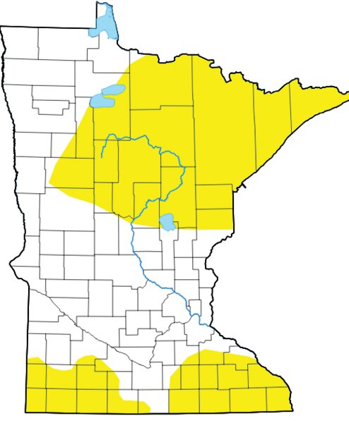
REGIONAL— Drought is creeping back into the picture in northeastern Minnesota as above-average temperatures and limited precipitation in recent weeks has parched soils and elevated fire danger.
According to the U.S. Drought Monitor, the entire Arrowhead is now classified as “abnormally dry,” the lowest level of drought category. Minnesota had been considered free of drought as recently as a few weeks ago after a wetter than normal start to the summer.
Much of that rain fell in a single event on June 18, when many parts of the region saw anywhere from three to eight inches of intense rainfall, which caused significant overland flooding. Rainfall in July was close to average, but since Aug. 1, rainfall has been running only about 60 percent of normal and minimal rain has fallen so far in September. Many reporting stations in the region, including Ely, Embarrass, and Cook, had seen less than two-tenths of an inch of rain in the first two weeks of the month— about an inch and a half below average. Combined with warmer-than-average temperatures so far this month, conditions have grown dry quickly.
In areas with shallow soils, the impact of what is essentially a flash drought has been dramatic, with many trees experiencing early color change and leaf wilt. The dry conditions have led to high fire danger across much of central St. Louis County, while conditions remain listed as moderate in northern St. Louis County. The area with high fire danger includes the Mesabi Iron Range north to Bear River and Sturgeon Township, east to Pike Township.
Lake and river levels are also falling quickly, particularly in central St. Louis County, where the St. Louis River is now well below its Q90, which means it’s lower than at present less than ten percent of the time. In northern St. Louis County, the Little Fork River’s flow fell 25 percent in the past week and is now below its Q75 level. With a similar decline this week, the Little Fork could well reach the Q90 stage by early next week. The DNR issues updated stream flow levels every Monday.


