Support the Timberjay by making a donation.

Flood forecasts for three Rainy River Basin waterways go live
REGIONAL- Under development since last year’s flooding, the National Weather Service and North Central River Forecast Center (NCRFC) on Monday unveiled three new forecast points within the …
This item is available in full to subscribers.
Attention subscribers
To continue reading, you will need to either log in to your subscriber account, below, or purchase a new subscription.
Please log in to continue |
Flood forecasts for three Rainy River Basin waterways go live
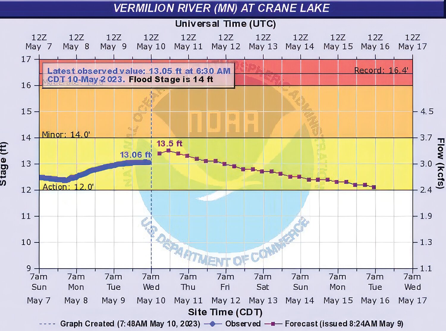
REGIONAL- Under development since last year’s flooding, the National Weather Service and North Central River Forecast Center (NCRFC) on Monday unveiled three new forecast points within the Rainy River Basin.
Instead of having basic river gauge data points, NCRFC now had the ability to predict flows and flood stages for the Vermilion River at Crane Lake, the South Kawishiwi River near Ely, and the Littlefork River at Littlefork for a period of seven days, and probability simulations for up to ten days from a forecast date.
“It’s definitely something that was spurred on by the flooding that we had last year,” said NWS Duluth office meteorologist Ketzel Levens. “It might have been in the works in the back of folks’ minds before that, but last year was definitely a very clear indicator of the lack of services up there, frankly, and how many places we had to grow with the services that we could provide for the Rainy River Basin.”
To develop the database necessary to support predictions, the NWS and NCRFC had to do a lot of research.
“We have to play history detective,” Levens said. “We worked off of not just last year’s flooding, but any of the flooding we’ve had in the past that we could find some kind of record of and then finding those historic impacts and tying them back to what levels and what flow the river gauges were at when those occurred.”
Impacts are how flooding affected areas near where the gauges are, and are related to the descriptions of flood stages – minor, moderate, and major. That meant understanding how certain levels and flows correlated with reported structure damage, for example.
“Is it just kind of nuisance flooding? Is it homes are being impacted? Is it widespread infrastructure impacts, those kinds of increasing levels,” Levens said.
Along with tying the data to flood stage levels, an “action” level was determined that would trigger the flood forecasting model. Testing of the model was initiated in the fall, making sure it was calibrated correctly.
This past fall and winter have provided some of the most robust data to feed into the model thanks to an extensive campaign to recruit more people to do precipitation observations.
“They play a huge role,” Levens said. “All winter we were collaborating really close with the forecasters at NCRFC to make sure we were all on the same page about how much liquid was in the snow, and that was based largely off the observations we were getting on the ground. We have some really dedicated folks near Ely and near Kabetogama and International Falls who were taking those snow water equivalent measurements every single week. From there we can balance the model out across the basin.”
And now, as the snow has turned to rain, those localized measurements are important because the NCRFC goes into the model every morning to be sure their precipitation estimate is balanced correctly with all of the ground observations, Levens said.
“If there are no observations in a loation, the precipitation is just based off of radar estimates, and the farther and farther you get away from the radar based here in Duluth the less accurate those estimates can be,” Levens said. “It really helps to have actual observation on the ground. It plays a huge role in river forecasting.”
The seven-day forecasts generated by the model include the next day’s precipitation forecast – if someone is looking at a river forecast point on a Monday, it factors in all the recorded precipitation up to the time of the forecast, plus the additional precipitation expected during the next 24 hours.
“The simulation is almost as if it stops raining after 24 hours,” Levens said. “That what that river simulation is showing you."
For some sophisticated computer-generated guesswork, people can access a short-term probability graph which plots the likelihood of a river being at a certain flood stage for 10 days beyond the forecast date by using a range of precipitation and temperature forecasts for that time period. The blue range of the graph indicates the most likely scenarios, and the information can be used as a supplement to the river forecast.
Additional river forecast points could be added over time, Levens said, depending on what data is available to build a model from.
“Some points that we’re looking at that would be several years down the line are those that are along the Canadian border,” Levens said. “There’s an extra hurdle that needs to be passed there, which is that those areas also strongly depend on the flows that are coming from the Canadian side of things and that is a side that is not necessarily run in our model yet.”
Levens said that they’re still looking for more observers for the basin. Information about the observer program is available at https://www.cocorahs.org/. Those who have additional questions after reviewing the site can contact Levens via email at ketzel.levens@noaa.gov, or by phone at 218-729-0653. River forecast points can be accessed at the following URLs:
Vermilion River at Crane Lake -- https://water.weather.gov/ahps2/hydrograph.php?wfo=dlh&gage=clkm5
South Kawishiwi River near Ely -- https://water.weather.gov/ahps2/hydrograph.php?wfo=dlh&gage=skrm5
Littlefork River at Littlefork -- https://water.weather.gov/ahps2/hydrograph.php?wfo=dlh&gage=lfkm5


