Support the Timberjay by making a donation.

Storm of the century?
A narrow band across north-central St. Louis County saw truly historic rainfall
REGIONAL— While last week’s storm poured immense amounts of rain all across the Arrowhead, some areas received much more than others. Tucked within a broad swath of generally two-to-four …
This item is available in full to subscribers.
Attention subscribers
To continue reading, you will need to either log in to your subscriber account, below, or purchase a new subscription.
Please log in to continue |
Storm of the century?
A narrow band across north-central St. Louis County saw truly historic rainfall
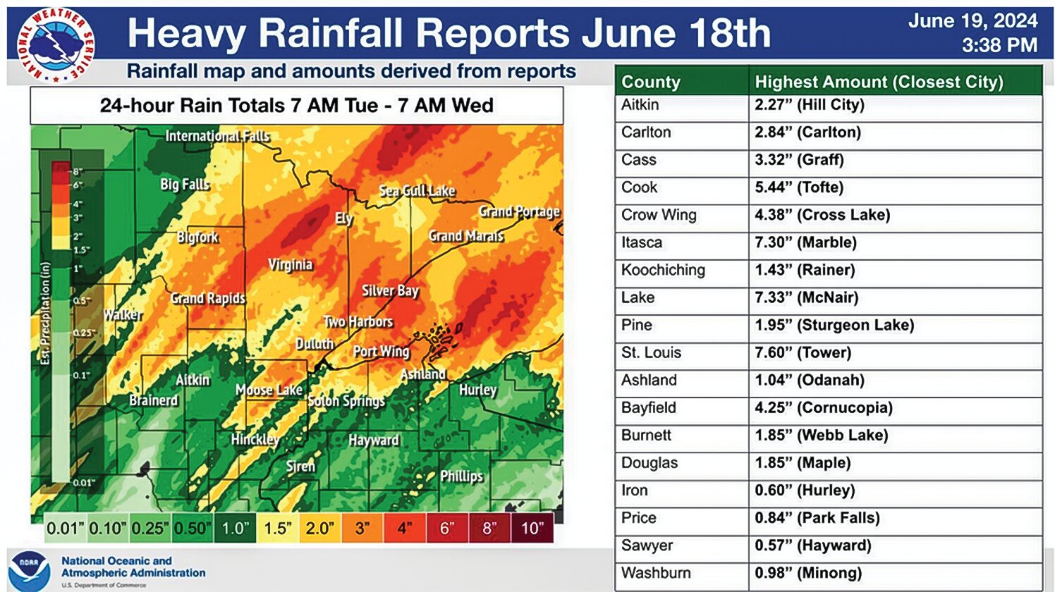

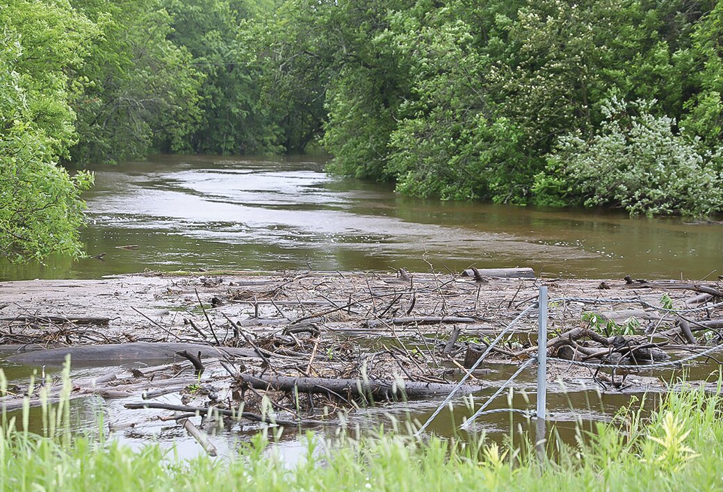


REGIONAL— While last week’s storm poured immense amounts of rain all across the Arrowhead, some areas received much more than others. Tucked within a broad swath of generally two-to-four inches of rain, were narrow bands that received significantly more, in some cases as much as eight to nine inches, and those areas typically experienced the most significant damage as a result.
A rainfall map produced by the National Weather Service’s Duluth office late last week showed the highest rainfall totals in a narrow band stretching from roughly Big Rice Lake, north of Virginia, to the northeast, extending through the center of the Trout Lake portion of the Boundary Waters. Areas around Pfeiffer Lake, Lost Lake, central Lake Vermilion, to Pine Lake in the BWCAW, were within this swath of the highest intensity rainfall.
The map is based primarily on estimates from radar, which provide a quick and initial estimate, which climatologists then attempt to “ground-truth” through other data, including reports from observers, which take more time to assemble.
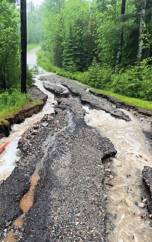
Among the official reports from on-the-ground rainfall observers, the highest total came from near Tower, where an official observer reported 7.6 inches. Some unofficial reports from just west of Tower suggested even higher amounts, in excess of eight inches. Those reports line up well with some of the most extensive damage to roads, including a major washout of a portion of Hwy. 1, which collapsed the roadway about five miles east of the intersection with Hwy. 53.
State climatologist Kenny Blumenthal said for places in northern St. Louis County, the threshold for a 100-year-rain event is 5.91 inches. For those places that received in excess of seven inches, he said the storm likely qualified as a 500-year event. “It was a big, big storm that definitely exceeded the 100-year threshold in a lot of places,” he said.
Intense rainfall and a long period of heavy rain combined to create the conditions for the extreme event, said Blumenthal. While heavy rainfall associated with the passage of a summer cold front is not unusual, Blumenthal said winds typically run perpendicular to cold fronts and help to push storms through an area relatively quickly, which limits the duration of intense rainfall. He said this particular cold front was slow-moving and the winds were aligned roughly parallel to the front, which pushed storms along the nearly stationary front for hours. “It was a very effective moisture delivery mechanism,” he said. “There was a lot of tropical moisture in the atmosphere and it created a train of storms that sat over the area.”
While June thunderstorms can often bring high winds and hail, Blumenthal said this event was largely limited to rain. There were no reports of hail nor significant wind damage. “When we get flash flooding, it tends to be just a rain event,” he said.
While last week’s deluge was a rarity, Blumenthal said the likelihood of such events is continuing to rise as the climate warms. “It’s not turning the former 100-year storm to a two-year storm,” said Blumenthal, “but it is making such events more likely to occur.”


