Support the Timberjay by making a donation.

Study to gauge carbon losses losses
Researchers using LIDAR to determine the impacts of the Greenwood fire
REGIONAL- “Nobody has done this before,” Randy Kolka told the Timberjay. Kolka is a soil scientist with the U.S. Forest Service and he was talking about a unique study to calculate how …
This item is available in full to subscribers.
Attention subscribers
To continue reading, you will need to either log in to your subscriber account, below, or purchase a new subscription.
Please log in to continue |
Study to gauge carbon losses losses
Researchers using LIDAR to determine the impacts of the Greenwood fire
REGIONAL- “Nobody has done this before,” Randy Kolka told the Timberjay. Kolka is a soil scientist with the U.S. Forest Service and he was talking about a unique study to calculate how much carbon is lost when peatlands burn.
“I estimate that tons and tons of carbon are lost when peat burns,” Kolka said. “Before now, we’ve had no good way to determine this … This time next year, I’ll know how much.”
The study, a cooperative project between Boise State University, the Superior National Forest, and the USFS Northern Research Station in Grand Rapids, will measure just how much carbon was lost from a large peatland located within the boundaries of the 2021 Greenwood fire, 20 miles southeast of Babbitt.
The research is only possible, however, because of an unusual Minnesota initiative that started in 2008 to collect elevation data across the entire state using a technology called LIDAR — “light detection and ranging.” It’s an older technology, invented in the 1960s that can map the ground surface with great detail and accuracy, as well as simultaneously map objects above the ground, like buildings, roads, and trees.
Because the equipment to collect LIDAR data must be flown by slow aircraft close to the ground, LIDAR surveys are expensive, labor-intensive, and require much more data processing that simpler techniques. Despite the time and expense, Minnesota embarked on collecting LIDAR for the whole state.
Minnesota’s LIDAR data, managed by the Department of Natural Resources, made the current research possible because it captured the ground surface of the peatlands burned in the 2021 Greenwood fire prior to the burn.
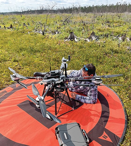
BSU and USFS personnel recently collected a new LIDAR dataset of the Greenwood fire scar. Professor Nancy Glenn’s research group in the BSA Geosciences Department sent out two researchers, Josh Enterkine and Thomas Van Der Weide, to fly BSU’s drone mounted LIDAR equipment. BSU has a long history of working with the USFS and other federal and state agencies which manage forests and fight wildfires.
The BSU researchers were aided on the ground by USFS staff who helped maintain safe skies for the low-flying drone, sometimes climbing trees to establish good lines of sight. The data collection phase of the project started on Aug. 28 and finished on Sept. 2.
Kolka, who is with the USFS Northern Research Station, is enthusiastic over what the data will show. “We’ve collected vegetation data, soil cores and made a detailed fire severity map of the fire scar.”
That post-fire LIDAR data will be compared with the pre-fire dataset to determine the loss of peatland elevation from the wildfire. In 2022, USFS soils staff collected peatland soil cores across a range of peatland ecosystems and burn severities within the Greenwood Fire burn perimeter. Further laboratory analyses from those samples, along with measured losses in peatland elevation will allow Forest Service research scientists to estimate overall loss of carbon and other greenhouse gases from the peatlands after the wildfire.
Peatlands are the largest, natural, terrestrial carbon sink and are believed to store more carbon than all other vegetation types in the world combined. The USFS can be more proactive with forest management in and around these climate-sensitive peatlands by understanding how fires affect them. More than a third of the forest area in northern Minnesota is comprised of peatlands.
The area of the study is in Superior National Forest, mostly in Lake County: south of Hwy. 1 and east of Cty. Rd. 2, west of the Stony River, and north of Greenwood Lake.


