Support the Timberjay by making a donation.

VNP issues revised frozen lake use proposal
Public comment period to run from May 28-June 28
REGIONAL- Voyageurs National Park officials on Monday released a revised version of their proposed Frozen Lake Surface Use Plan, a measure that generated intense blowback from the public when the …
This item is available in full to subscribers.
Attention subscribers
To continue reading, you will need to either log in to your subscriber account, below, or purchase a new subscription.
Please log in to continue |
VNP issues revised frozen lake use proposal
Public comment period to run from May 28-June 28
REGIONAL- Voyageurs National Park officials on Monday released a revised version of their proposed Frozen Lake Surface Use Plan, a measure that generated intense blowback from the public when the first iteration was proposed in April of last year.
According to park officials, the plan is needed to bring the park into compliance with federal policies and regulations for the use of motor vehicles within national parks. Those regulations prohibit the operation of motor vehicles except on park roads, and in parking areas. According to the document issued by VNP on Monday, routes and areas for off-road motor vehicle use may not be designated in national parks, meaning the current dispersed use of such vehicles on the park’s frozen lake surfaces is inconsistent with regulations.
Comments taken at two public hearings, a third virtual hearing, and submitted in writing were compiled, analyzed, and used to inform the revised proposal, according to VNP Superintendent Bob DeGross, who said he hopes the public will continue to be engaged in the review process.
“We encourage the public to review the new alternative and provide their comments,” DeGross told the Timberjay on Monday. “My main goal is to allow for a reasonable amount of access within the regulations defined by the National Park Service, while assuring the protection of resources and being mindful of the range of visitors who seek to enjoy the park. I hope that the new alternative will demonstrate our willingness to create the balance that considers all of those concerns.”
The Frozen Lake Surface Use Plan document lists four alternatives, two of which appear to be non-starters. Alternative one would be to leave things the way they are, an option the document clearly states is “not selectable” due to the conflict with applicable regulations. Alternative four would restrict access to snowmobiles only, with no ice roads, and ice fishing shelters would have to be transported only by snowmobiles in both the moderate and low-use zones that would be established.
That leaves alternative two, the original frozen lake plan, and alternative three, the revised plan, as the only viable options on the table.
Absent from the revised plan are the moderate and low-use management zones proposed in the original plan. Moderate use zones would have been established on Rainy and Kabetogama lakes, while low-use zones would have been created on Namakan, Sand Point, Mukooda, Rainy, and all interior lakes, including those associated with designated snowmobile trails. Motor vehicles other than snowmobiles would have been allowed within 300 feet of the centerline of ice roads in moderate use areas and prohibited in low-use areas. The park would have established and maintained up to 26 miles of ice roads under the original proposal, and a one-time use or seasonal access pass would have been charged to visitors.
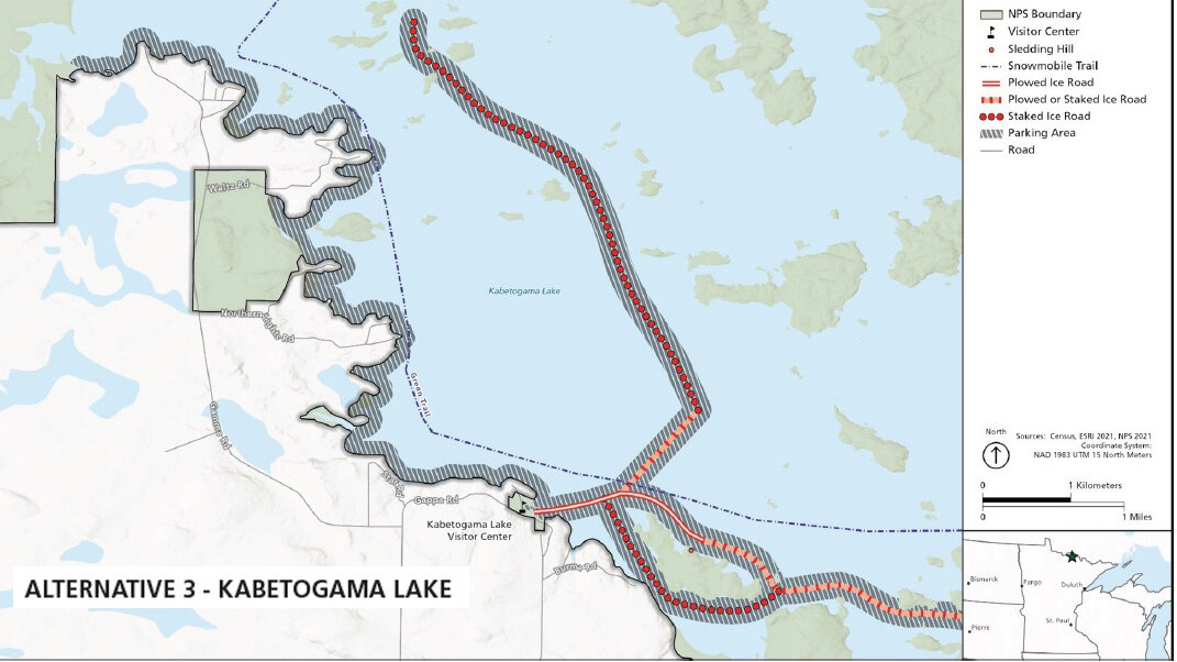
In the revised plan, parking areas along ice roads would be expanded from 300 to 500 feet from the center line, and also allowed along Lake Kabetogama’s developed shoreline. Individuals would be allowed to plow in parking areas to facilitate placement of ice shelters.
The revised plan designates two types of park-established ice roads – plowed and staked. Staked roads would be unplowed and ungroomed. According to the plan, “any state-registered and/or licensed motor vehicle would be allowed to use plowed and staked ice roads as long as they adhere to weight restrictions.” Up to 32 miles of plowed and staked roads would be allowed under the revised plan, although the plan appears to allow for up to 17 miles of plowed roads and 29.3 miles of staked roads, 14.3 more than the stated 32 miles.
“As to the mile of roads, this can be a bit confusing,” DeGross acknowledged. “Traditionally, when conditions allow, we attempt to establish 15 miles of ice roads on Rainy and 12 miles on Kab, for a total of 27. In the most recent alternative, we are proposing to add about two miles on Rainy and about three on Kab, this gives us a total of 32 miles of potential ice roads, 17 on Rainy and 15 on Kab. We will establish staked ice roads once we attain a minimum of eight inches of ice that allows for safe travel of lighter types of vehicles. Some of the staked ice roads will be converted to plowed ice roads once an ice thickness of 13 inches is reached. We are proposing that on Rainy, of the 15 miles of roads seven may be plowed and eight will remain as staked ice roads. On Kab about ten miles will be plowed and the remaining five miles will remain as staked ice roads. We are open to hearing from the public on this concept during this public scoping period. One thing we always have to be mindful of is how to maintain what we establish.”
Modifications have also been made in the revised plan to the requirements regarding ice shelters.
Originally, the park proposed that ice shelters in low-use zones could only be transported by snowmobiles and had to be occupied, with commercial use authorization holders allowed to seek approval for longer-term placements.
Now with the revisions, there is no low-use zone to contend with, and park officials would allow permanent ice shelters that adhere to state regulations that can be left unoccupied. Transportation of shelters by motor vehicles would be allowed along ice roads and within parking areas, while shelter transport not associated with an established ice road would require the use of a snowmobile. Ice shelter placement and ice openings cannot be within 50 feet from the edge of plowed roads or 100 feet from the center of staked roads.
Common to both plans is the imposition of access fees for motor vehicle use.
Comment
opportunities
The public comment period will open on Tuesday, May 28 and end on Friday, June 28.
Two in-person public meetings will be held, as follows:
• Wednesday, June 12 in the Commons Area of the Rainy River campus of Minnesota North College at 1501 Hwy 71 in International Falls, from 6-8 p.m.
• Thursday, June 13 at the Kabetogama Town Hall at 9707 Gamma Rd. in Kabetogama, from 6-8 p.m.
An online virtual meeting via Zoom will be held on Monday, June 10 from 6-8 p.m. Attendees should log in to the meeting link, https://us02web.zoom.us/j/85795779224, five to ten minutes early to test their connection. The audio portion of the meeting can also be accessed by telephone by calling 312-626-6799 and entering the webinar ID number 857 9577 9224.
Written comments may be submitted at any time during the comment period. Online submissions can be made at https://parkplanning.nps.gov/VOYA-frozen. Comments can also be mailed to Frozen Lake Surface Plan, Voyageurs National Park, 360 Hwy 11 East, International Falls, MN 56649. All comments must be received no later than June 28.
This period initiates the National Environmental Policy Act (NEPA) process, and comments collected will be used to help develop an environmental assessment that would be presented for public comment in late fall. The NEPA process would likely be completed over the winter months, with the final plan and a timeline for its implementation anticipated by spring 2025.
You can access the newsletter detailing the proposed plan with maps by going online to https://parkplanning.nps.gov/VOYA-frozen. There, click on the blue “Document List” link and select “*NEW* Public Scoping Newsletter for Frozen Lake Surface Use Plan/EA (May 2024).”


